
England &
Wales Hardwicke Marriage Index
Marriages 1754 - 1837
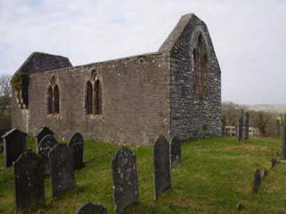
Rhostie
St Michael
|
|
England &
Wales Hardwicke Marriage Index |
The ParishThe parish of Rhostie lies in the northern part of central Cardiganshire. Rhostie is a tiny place, it doesn't even merit a mention on today's Ordnance Survey maps. Rhostie is located about 7 miles southeast of the seaside town of Aberystwyth and just west of the A485 road which links Aberystwyth with Tregaron and Lampeter. Rhostie is not a village, just an area of remote countryside centred on the church of St Michael. A dead-end road heads west from Rhos-y-garth and leads to the church, the parish covered a small area around this site. The area is almost exclusively used for pastoral farming with sheep predominating on the poor pastures. Rhostie is sited at about 140 metres above sea level, although land rises to the southwest to over 200 metres. All of the drainage is headed northwards to join the Afon Ystwyth at Llanilar. Rhostie parish was also tiny and covered a very small area unlike its neighbours, it barely supported 150 parishioners. Like most of Wales Rhostie is not mentioned in Domesday Book. |
 |
|
|
|
| Register No | Covering Dates | Deposited With | Register Style | Quality Standard | Comments |
| 1754 - 1821 | No registers exist covering this period | ||||
| 1 | 13th November 1822 - 23rd June 1837 | Ceredigion Archives - Aberystwyth - Reference PR/RHO/2 | Standard Rose style preprinted and prenumbered Marriage register | Grade 1 Register - Few issues noted and a low likelihood of misreads | None |
|
Llanilar
St Ilar
|
Llanilar St
Ilar
|
Llanilar
St Ilar
|
|
Llanilar St
Ilar
|
 |
Llanilar St
Ilar
|
|
Lledrod
St Michael
|
Lledrod St
Michael
|
Lledrod
St Michael
|
Corrections to Tinstaafl Transcripts