
England
& Wales Hardwicke Marriage Index
Marriages
1754 - 1837
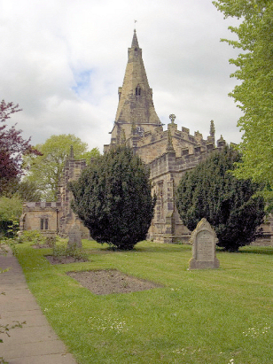
Horsley St Clement
| |
England
& Wales Hardwicke Marriage Index |
The ParishThe parish of Horsley lies in eastern Derbyshire roughly 6 miles north of the county town of Derby. Horsley sits a quarter mile east of the A38 road which links Derby through to the M1 motorway and Alfreton. The village of Horsley, which holds the parish church, is just one of the villages within the parish, it is a curve of properties on a spur of a hill culminating in the church at its western end, to the east sits Horsley Woodhouse and to the north Kilburn both linear settlements along the A609 road between Belper & Smalley. The area has a long history, to the south of Horsley sits the site of Horsley (or Horston) Castle which existed as early as the mid-12th century and stands on the western end of a spur overlooking the valley below, the stonework has been robbed over the centuries leaving merely the earthworks as a reminder. Much of the parish was set to pasture but the quarries hereabouts also tell of much extraction of the local stone and not just from the castle. Like many East Midlands communities the ubiquitous framework knitting trade also employed many in Horsley. Modern developments have come to the parish both exploiting the tributary valley of the Derwent below the village, the railway line which followed this feature is now closed but the A38 has been upgraded to fast dual-carriageway highway speeding traffic from eastern Staffordshire as well as Derbyshire to the M1. Horsley is drained southwards by that tributary which joins the Derwent at Little Eaton, the Derwent passes through Derby, turns southeast and meets the Trent to join that river's long journey back north to the North Sea through the Humber Estuary. Horsley is sited at around 100 metres above the sea with the subsidiary villages perhaps 10-20 metres higher in undulating terrain, to the south Drum Hill (156 metres) is the highest ground around. Covering just under 2,700 acres Horsley parish was typical of this area in being more extensive, it would have supported a population of close to 2,250 parishioners. Domesday Horsley was a much smaller place held by Ralph de Buron it had just 23 households and mustered 8 ploughs backed by some meadows and woodland. |
 |
|
|
|
| Register No | Covering Dates | Deposited With | Register Style | Quality Standard | Comments |
| 1 | 17th April 1754 - 3rd October 1769 | Derbyshire Record Office | Bishops' Transcripts on loose-leaf folios | Grade 3 Register - there are sufficient quality issues with this register to indicate that some misreads will occur albeit few in number | The register suffers at times with bleed-through making for tricky reading and the likelihood of misreads. It would appear that the BTs for 1763 - 1766 have been lost |
| 2 | 14th November 1769 -21st December 1801 | Derbyshire Record Office - Reference - D2467/A/PI/3/1 | Plain, unruled book containing combined Banns & Marriages | Grade 2 Register - not a perfect read but with a low likelihood of
misreads |
None |
| 3 | 28th February 1802 - 28 December 1812 | Derbyshire Record Office - Reference - D2467/A/PI/3/2 | Standard preprinted and self-numbered Marriage register with 3 entries per page | Grade 2 Register - not a perfect read but with a low likelihood of
misreads |
None |
| 4 | 14th April 1813 - 8th June 1837 | Derbyshire Record Office - Reference - D2467/A/PI/3/3 | Standard Rose style preprinted and prenumbered Marriage register | Grade 3 Register - there are sufficient quality issues with this
register to indicate that some misreads will occur albeit few in
number |
Fading in places in this register may lead to one or two misreads |
|
Duffield
St Alkmund
|
Denby
St Mary
|
Denby
St Mary
Smalley St John the Baptist |
|
Duffield
St Alkmund
|
 |
Smalley
St John the Baptist
|
|
Breadsall
All Saints
|
Breadsall
All Saints
|
Morley
St Matthew
|
1760 1770 1780 1790 1800 1810 1820 1830
Corrections to Tinstaafl Transcripts