
England
& Wales Hardwicke Marriage Index
Marriages
1754 - 1837
Plympton St Mary
| |
England
& Wales Hardwicke Marriage Index |
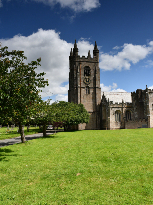
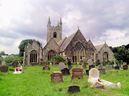
The ParishThe parish of Plympton St Mary lies in the extreme southwest of Devon roughly 5 miles northeast of the port of Plymouth. Plympton sits on the former route of the A38 road which connects Plymouth with Exeter, that road has been downgraded to the B3416 and the modern A38 expressway bypasses the town to its south. Plympton has a longer history than its nowadays much larger neighbour, in the early Middle Ages it was a town & port of much greater importance than Plymouth. Created a borough by Henry I in the early 12th century. An Augustinian priory founded in 1121 was an important land owner for much of this area of southwestern Devon and centred its operations upon the parish of St Mary. It is certainly unusual for a smallish market town to hold two distinct parishes, the smaller St Maurice being formed as a tiny area of the former borough whilst St Mary incorporates much of the remainder of the town as well as the rural area containing the villages of Ridgeway, Underwood, Colebrook, Hemerdon, Sparkwell, Venton, and Lee Mill Bridge. Whilst Plymouth grew with its naval connections, Plympton remained a small port and market town. It also exploited its geology with slate & paving stone being quarried as well as extraction of the typical copper & tin mines of the district. The wider parish would have primarily been used for the typical pastoral farming regime of western Devon, with dairy cattle the main component. Its coastal situation also made fishing and shell-fisheries important for a diverse economy. Modern developments have arrived in the town, Brunel's Great Western Railway passing through en route from London to Cornwall and the relatively recent upgrading to of the A38 to neat motorway standard has certainly helped to improve the traffic situation in the town. Today's Plympton is, however, almost engulfed by the spread of Plymouth's suburbs across the River Plym making it an eastern part of a substantial urban conurbation stretching for almost 10 miles from the western edges of Saltash in Cornwall through to Plympton's eastern edges. A small fast flowing stream the Troy runs through the centre of town drainig the parish into the nearby River Plym and hence the English Channel. Plympton is sited at between sea level and almost 115 metres, at some properties in Langage, the wider parish rising to well over 250 metres on the southern edges of nearby Dartmoor. Plympton St Mary was considerably the larger of the twin parishes, covering a little over 9,500 acres it was one of the larger in its county and within that extensive acreage would have been supported close to 2,700 parishioners. In Domesday times Plympton was counted as a single royal-held entity and was already one of the largest 20% of settlements recorded by population, its assets of just 18 ploughs together with meadows, pastures & woodland belie its importance at the time. |
 |
|
|
|
| Register No | Covering Dates | Deposited With | Register Style | Quality Standard | Comments |
| 1 | 25th March 1754 - 14th April 1783 | Plymouth & West Devon Record Office - Reference - 414/10 | Plain, ruled & bordered book containing combined Banns & Marriages | Grade 1 Register - Few issues noted and a low likelihood of misreads | None |
| 2 | 27th May 1783 - 24th November 1812 | Plymouth & West Devon Record Office - Reference - 414/11 | Standard preprinted and self-numbered Marriage register with X entries per page | Grade 2 Register - not a perfect read but with a low likelihood of
misreads |
None |
| 3 | 1st January 1813 - 15th May 1837 | Plymouth & West Devon Record Office - Reference - 414/12 | Standard Rose style preprinted and prenumbered Marriage register | Grade 2 Register - not a perfect read but with a low likelihood of
misreads |
None |
|
Egg
Buckland St Edward
|
Shaugh
Prior St Edward
|
Cornwood
St Michael
|
|
Egg
Buckland St Edward
|
 |
Cornwood
St Michael
|
|
Ermington
St Peter & St Paul
|
1760 1770 1780 1790 1800 1810 1820 1830
Corrections to Tinstaafl Transcripts