
England
& Wales Hardwicke Marriage Index
Marriages
1754 - 1837
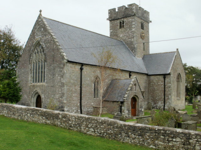
Coity St Mary
| |
England
& Wales Hardwicke Marriage Index |
The ParishThe parish of Coity lies in southern Glamorgan roughly 2 miles northeast of the modern industrial town of Bridgend, indeed the wider parish includes a substantial portion of eastern Bridgend. Coity sits just under a mile east of the A4061 road which forms Bridgend's eastern bypass. The village of Coity, a small and compact village gathered around its 12th century ruined castle and its church, is by far the largest settlement within the parish. Bridgend is a major urban centre stretching for several miles along the valley of Afon Ogwr and modern developments spread substantially into Coity parish. In addition smaller settlements such as Pen-yr-hoel & Pant-y-pyllau are mere hamlets. One cannot discuss Coity without reference to its ruined castle which dominates the village despite its ruinous condition. The keep from the late 12th century is enclosed within a curtain wall and outer ward roughly 120 feet in diameter. Pevsner states it to be the most impressive ruined medieval castle after Caerphilly in Glamorgan. The parish is typical of much of the Vale of Glamorgan with pastoral farming a speciality, Bridgend became the regional market town and in modern times has attracted much industry. A substantial extractive industry of mines and quarries also employed many within the parish. Modern developments have come to the parish, the Brridgend to Maesteg railway line scraping into the parish area to the west whilst to the north the modern M4 passes through en route from Cardiff to Swansea. Despite the close presence of Afon Ogwr to the west Coity drains southwards into the Ewenny River which only meets the Ogwr just before entering the outer Bristol Channel. Coity is sited at around 60 metres above the sea overshadowed by the low ridge of Cefn Hirgoed to its north which reaches 134 metres, beyond to the north rise the fore-hills of mightier hills with wind-farm topped Mynydd Maendy just crossing the 300 metres contour. Coity parish was an extensive one covering just under 4,600 acres and divided into High Coity and Lower Coity, the population being close to 1,900 parishioners. Like most of Wales Coity is not mentioned in Domesday Book which did not cover this area. |
 |
|
|
|
| Register No | Covering Dates | Deposited With | Register Style | Quality Standard | Comments |
| 1 | 20th November 1754 - 25th November 1757 | Glamorgan Archives - Cardiff - Reference P80/CW/1 | Plain, unruled book, a continuation of the extant composite register in contravention of Hardwicke's segregation & wording requirements | Grade 2 Register - not a perfect read but with a low likelihood of misreads | None NB the register also contains 7 marriages held at Nolton which are included here |
| 2 | 12th December 1759 - 30th May 1791 | Glamorgan Archives - Cardiff - Reference P80/CW/3 | Standard preprinted and self-numbered Marriage register with 4 entries per page | Grade 2 Register - not a perfect read but with a low likelihood of misreads | None |
| 3 | 9th October 1791 - 25th December 1812 | Glamorgan Archives - Cardiff - Reference P80/CW/4 | Standard preprinted and self-numbered Marriage register with 3 entries per page | Grade 1 Register - Few issues noted and a low likelihood of misreads | None |
| 4 | 8th May 1813 - 8th June 1837 | Glamorgan Archives - Cardiff - Reference P80/CW/5 | Standard Rose style preprinted and prenumbered Marriage register | Grade 2 Register - not a perfect read but with a low likelihood of misreads | None |
|
St
Brides Minor St Bride
|
St
Brides Minor St Bride
|
Coychurch
St Crallo
|
 |
Coychurch
St Crallo
|
|
|
Ewenny St Michael
Coychurch St Crallo
|
Coychurch
St Crallo
|
1760 1770 1780 1790 1800 1810 1820 1830
Corrections to Tinstaafl Transcripts