
England
& Wales Hardwicke Marriage Index
Marriages
1754 - 1837
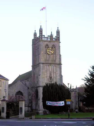
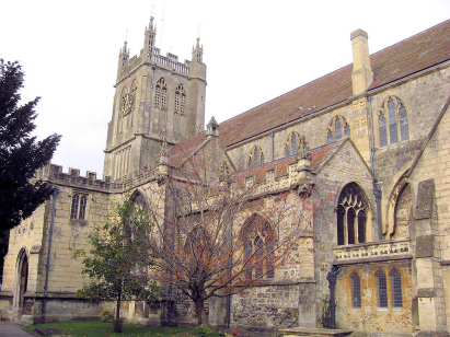
Dursley St James
| |
England
& Wales Hardwicke Marriage Index |
The ParishThe parish of Dursley lies in the southern portion of central Gloucestershire roughly 15 miles southwest of the county town of Gloucester. Dursley is a market town which sits, tucked away in a tightly incised valley in the escarpment of the Cotswold range, on the A4135 road, this road rises up from the busy A38 passes through Dursley and heads to Tetbury. Given its location in a valley with steep sides most of the properties are strung out along the valley bottom, more modern developments rise up these slopes both to north and south. Earliest references to Dursley place its origins in the Saxon period but it was not until Roger de Berkeley founded a castle here in the mid-12th century that a town was formed. Granted its market around in 1471 by King Edward IV it became a trading point for the regions produce as well as the location for specialist services. The small area of the parish had some farming, mostly pastoral. For many years the fast-flowing River Ewelme powered mills such that by the early 16th century Dursley was one of the principal cloth producing centres of the Cotswolds, the fulling mills have all gone nowadays to be replaced by an engineering works and general light industry & services. The distinctive local stone, a tufa, used in the castle, which was demolished in Tudor times, was also extensively quarried and used for local building stone. Modern developments have largely been and gone, a branch railway line from Coaley junction on the main Bristol to Gloucester line has since closed and been largely removed, the modern M5 motorway keeps away from the slopes of the Cotswolds and runs some 3 miles to Dursley's west. The Ewelme drains the parish westwards and then northwest across the Severn plains to join that river, but much man-altered in its course, through the grazing marshes of The Warth. Dursley is sited at around 70 metres above the sea with some of its modern suburbs at close to 120 metres up the valley sides, the town is overlooked by the isolated local peak of Downham Hill which rises to a metres short of 200 metres and by Cam Long Down which overtops by a further 10 metres. Dursley parish was largely confined to the town and an immediate hinterland, covering just over 900 acres it still supported a population of close to 2,900 parishioners. Dursley's entry in Domesday Book is perhaps difficult to believe, held directly by King William, himself, it claims to hold an incredible 197 ploughs, surely this is a regional figure rather than the actual count of the town, that it also held an impressive 10 mills alludes to the source of its future wealth and is much more credible and indicative of its asset value to the king, |
 |
|
|
|
| Register No | Covering Dates | Deposited With | Register Style | Quality Standard | Comments |
| 1 |
15th April 1754 - 28th July 1765 |
Gloucestershire Archives - Reference - P124/IN/1/5 |
Standard preprinted and self-numbered Marriage register
with 4 entries per page |
Grade 2 Register - not a perfect read but with a low
likelihood of misreads |
None |
| 2 | 26th September 1765 - 3rd December 1786 | Gloucestershire Archives - Reference - P124/IN/1/6 | Standard preprinted and self-numbered Marriage register with 4 entries per page | Grade 1 Register - Few issues noted and a low likelihood of
misreads |
None |
| 3 | 26th December 1786 - 19th October 1800 | Gloucestershire Archives - Reference - P124/IN/1/8 | Standard preprinted and self-numbered Marriage register with 3 entries per page | Grade 2 Register - not a perfect read but with a low likelihood of
misreads |
None |
| 3 | 1st February 1801 -25th December 1812 | Gloucestershire Archives - Reference - P124/IN/1/9 | Standard preprinted and self-numbered Marriage register with 3 entries per page | Grade 2 Register - not a perfect read but with a low likelihood of
misreads |
None |
| 4 | 4th February 1813 - 18th June 1837 | Gloucestershire Archives - Reference - P124/IN/1/11 | Standard Rose style preprinted and prenumbered Marriage register | Grade 2 Register - not a perfect read but with a low likelihood of
misreads |
None |
|
Cam
St George
|
Cam St
George
|
Uley
St Giles
|
|
Cam St
George
Stinchcombe St Cyr |
 |
Uley St
Giles
|
|
North
Nibley St Martin
|
North
Nibley St Martin
|
Uley
St Giles
North Nibley St Martin |
1760 1770 1780 1790 1800 1810 1820 1830
Corrections to Tinstaafl Transcripts