
England
& Wales Hardwicke Marriage Index
Marriages
1754 - 1837
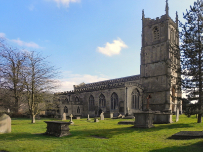
Wotton under Edge St Mary the Virgin
| |
England
& Wales Hardwicke Marriage Index |
The ParishThe parish of Wotton under Edge lies in southern Gloucestershire roughly 10 miles southwest of the the industrial town of Stroud and some 18 miles northwest of the city & port of Bristol. Wotton under Edge is a small market town which sits on the B4060 road which connects Yate with Cam running along the base of the Cotswold Hills. An important settlement, as will be seen below, in Domesday times Wotton under Edge met with something of a disaster in the early 13th century, during the reign of King John, when the existing town was largely destroyed by fire. A new town was founded c1252 relaid out largely to the west of the church; the town was granted the right to a market soon after. Wotton under Edge is intimately associated with cloth production, the Cotswolds, on the edge of which Wotton is situated, being famed for their sheep. Flemish weavers expelled from the continent soon settled in the town bringing their skills to the trade and further developing the industry, such was the growth that the tiny chalk stream flowing through the town was lined with mills powering production. Throughout the period of this transcript the industry continued to prosper but industrial revolution in the north and the growth of mechanised production encouraged decline in the traditional Cotswold centres and today the town is somewhat preserved in aspic as a result. Nevertheless the town still functions as a trading centre for the local area, a centre for light industry and in the wider parish a largely arable farming regime. The steep and irregular slopes of the Cotswold escarpment precluded railway development further eroding Wotton's advantages. That small stream mentioned above drains the parish southwestwards to join the nearby Little Avon River, turning northwestwards to meet the outer Severn Estuary at Berkeley. Wotton under Edge sits within a steeply sided valley etched into the Cotswold escarpment, in the valley bottom it sits at around 70 metres above the sea whilst its higher and more modern suburbs are at 140 metres on Wotton Hill, needless to say land rises much higher eastwards onto the Cotswolds proper topping out at just short of 250 metres above nearby Uley. As befits a market town, Wotton under Edge parish was fairly extensive, covering just under 4,900 acres it would, together with all of its adjoining hamlets, have supported a population of around 4,700 parishioners. Wotton under Edge's entry in Domesday Book is quite simply astonishing, retained directly by King William it was an incredibly profitable holding worth 170 pounds per annum, a stunning sum in today's exchange rates; in addition to this profit for the exchequer the book records almost 200 ploughs and 10 mills, the cloth industry clearly being present as early as the late 11th century. |
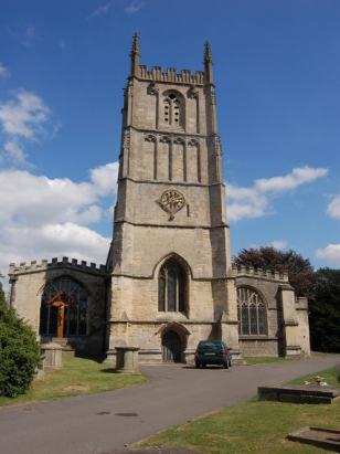 |
St Mary
the Virgin's church sits on the southern side of the B4058 road
(Culverhay) which heads northeastward from the town centre to
climb onto the Cotswold ridge. Like the remainder of the early
town the church which preceded this structure was destroyed in the
fire and nothing remains earlier than the 13th century.
Documentary evidence records a re-consecration in 1283. The only
notable features documenting the 13th century are traces within
the southern doorway (much restored) whilst internally the six-bay
arcades show that Early English Gothic style. The 14th century and
the twin styles of the Decorated & Perpendicular are what
largely define the church. The basal stages of the western tower
and the chancel show features of the Decorated period, the
latter's windows intermixed with the later 14th century
Perpendicular style, similarly the top stages of the tower reflect
that style change. Over the centuries the church has received many
modifications, the nave roof was raised in the 15th century to add
in a light-bringing clerestory and the southern porch was rebuilt
in 1658. The 19th century saw much change with a requirement for
increased accommodation for the growing congregation, this saw the
destruction and rebuild of the original chancel arch and screens
as well as the loss of an 18th century pulpit and the Early
English Gothic doorway. Further work followed in the 1870s and as
recently as 1903 the tower's pinnacles were remodelled in a more
slender form. Culverhay has street parking but is limited and side
roads may be sought as a better option. A low limestone wall
fronts the road with the main entrance at the western end of the
site where a tarred way leads to the entrance. The churchyard is
extensive and whilst there are a few trees they do not
substantially challenge the photographer.
|
|
|
| Register No | Covering Dates | Deposited With | Register Style | Quality Standard | Comments |
| 1 |
25th July 1754 - 21st May 1769 |
Gloucestershire Archives - Reference - P379/IN/1/11 |
Plain, ruled & bordered book containing combined Banns
& Marriages |
Grade 2 Register - not a perfect read but with a low
likelihood of misreads |
None |
| 2 | 26th May 1769 - 24th September 1783 | Gloucestershire Archives - Reference - P379/IN/1/12 | Plain, ruled & bordered book containing combined Banns & Marriages | Grade 2 Register - not a perfect read but with a low likelihood of
misreads |
None Nb the marriages are written from the back of the book forwards |
| 3 | 19th October 1783 - 28th February 1803 | Gloucestershire Archives - Reference - P379/IN/1/13 | Standard preprinted and self-numbered Marriage register with 4 entries per page | Grade 3 Register - there are sufficient quality issues with this register to indicate that some misreads will occur albeit few in number | Poor handwriting at times may lead to one or two misreads. NB the register runs out of marriages grids in early 1802 the clerk continues by overwriting the Banns grids with marriages |
| 4 | 10th April 1803 - 30th December 1812 | Gloucestershire Archives - Reference - P379/IN/1/14 | Standard preprinted and self-numbered Marriage register with 3 entries per page | Grade 1 Register - Few issues noted and a low likelihood of
misreads |
None |
| 5 | 8th February 1813 - 27th June 1837 | Gloucestershire Archives - Reference - P379/IN/1/15 | Standard Rose style preprinted and prenumbered Marriage register | Grade 1 Register - Few issues noted and a low likelihood of misreads | None |
|
North
Nibley St Martin
|
North
Nibley St Martin
|
Uley
St Giles
Owlpen Holy Cross |
|
Kingswood
by Wotton St Mary
|
 |
Kingscote
St John
Newington Bagpath St Bartholomew Ozleworth St Nicholas |
|
Kingswood
by Wotton St Mary
|
Alderley
St Kenelm
|
Alderley
St Kenelm
|
1755 1760 1765 1770 1775 1780 1785 1790 1795 1800 1805 1810 1815 1820 1825 1830 1835
Corrections to Tinstaafl Transcripts