
England
& Wales Hardwicke Marriage Index
Marriages
1754 - 1837
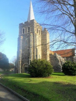
Minster in Thanet St Mary
| |
England
& Wales Hardwicke Marriage Index |
The ParishThe parish of Minster, the qualifier is required to separate it from the other on Sheppey, lies in the extreme northeast of Kent forming a short stretch of the county's North Sea coastline. Minster is located roughly 5 miles west of the coastal resort of Ransgate and sits south of the S299 road which links Ramsgate with Herne Bay and onward toward Faversham. Minster is a large village stretching for almost 3/4 of a mile from north to south along the lane connecting the A299 with its railway station, eastward and westward extensions are relatively short and relatively modern being expansion caused by the arrival of the railway in 1846. Minster has a long history of monastic occupation which began as early as the 7th century and, despite the depredations of Norse invaders, flourished until Henry VIII's dissolution. Minster sits upon the southwestern corner of the former Isle of Thanet, a true isle in early times nowadays surrounded by reclaimed land which is mainly used for grazing. In early times ships could pass to Minster and it served as a small port too. Modern developments have come to the parish, as already mentioned the railway linking Ramsgate into Canterbury arrived in 1846 granting Minster a station and a further line to Deal leaves at Minster's junction. Much of the A299 has also been upgraded to dual-carriageway highway to speed holiday traffic to their weekend destinations. Much of Minster's drainage is man-influenced but it sits above the outlets of the River Stour which flows into the nearby North Sea through a convoluted course via Sandwich. Minster is sited on a rising site the southern portion being close to sea level whilst by its northern edge it has risen to 35 metres, the former isle of Thanet has a general height of around 50 metres to the northeast. Given the extent of reclaimed land it is not surprising that Minster has an extensive acreage, covering almost 5,600 acres it would have supported a population of close to 1,400 parishioners. In Domesday times Minster was an exceptional settlement, its 242 households easily placing it amongst the largest settlements recorded and certainly in the top 20% if not top 5% of settlements recorded. Its assets were immense and shared between the Archbishop of Canterbury and its Abbey they made it one of the wealthiest settlements recorded, a huge 124 ploughs are recorded and that phenomenal number is backed by 8 salthouses, 2 fisheries and a mill as well as extensive meadows and woodland; perhaps the wealthiest settlement recorded in its day. |
 |
|
|
|
| Register No | Covering Dates | Deposited With | Register Style | Quality Standard | Comments |
| 1 |
24th May 1754 - 19th September 1812 |
Canterbury Cathedral Archives - Reference - CCA-U3-164/1/7 |
Standard preprinted and self-numbered Marriage register
with 4 entries per page |
Grade 2 Register - not a perfect read but with a low
likelihood of misreads |
None |
| 2 | 16th January 1813 - 29th March 1837 | Canterbury Cathedral Archives - Reference - CCA-U3-164/1/8 | Standard Rose style preprinted and prenumbered Marriage register | Grade 2 Register - not a perfect read but with a low likelihood of misreads | None |
|
Monkton
St Mary Magdalene
|
Birchington
All Saints
|
Thanet
St John
|
|
Monkton
St Mary Magdalene
|
 |
Thanet
St Lawrence
|
|
|
1760 1770 1780 1790 1800 1810 1820 1830
Corrections to Tinstaafl Transcripts