
England
& Wales Hardwicke Marriage Index
Marriages
1754 - 1837
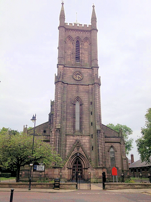
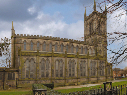
Chorley St George
| |
England
& Wales Hardwicke Marriage Index |
The ParishThe market town of Chorley lies in central Lancashire roughly 10 miles south of the town of Preston & about 25 miles northwest of Manchester. Chorley sits on the route of the A6 road from London to Carlisle at the foot of the Pennine Hills which rise eastwards from the Lancashire plain. Chorley is a town which grew massively in the 19th century as a result of a combination of the industrial revolution and of the modern developments that arrived to power it. Granted a market by Edward IV Chorley spent much of its history simply as a regional market and centre for specialist trades which required a larger area to support. With industrialisation came coal mining to support the growing industries which included the iconic weaving of much of the Pennine fringe towns. In addition to these industries, Chorley had 8 mills employing around 800 persons, the town had printing & bleaching works, a corn mill and iron foundries making it the typical Lancashire industrial mill-town. The more rural areas of the parish would have been farmed almost equally between arable and pastoral methods. Modern developments have arrived in abundance starting with the Leeds-Liverpool Canal which passes through the east of the town, two railway lines followed, the West Coast line from London to Glasgow passing to the west whilst a branch line connected Preston with Bolton through Chorley. Today Chorley is surrounded too with motorways, to the west the M6 and to the east the M61 provide excellent communications which keep Chorley as an important employment centre and regional market. Such was the growth of population that St George's parish was created from the parish church of St Lawrence in 1825 to support the expanded population. Chorley is drained westwards by the River Forrow which meets the Douglas to the east of Tarleton and turning north to join the estuary of the Ribble into the Irish Sea. Chorley is sited on a rising site with the western suburbs at 40 metres whilst those to the east are at 90, land rises increasingly steeply into the Pennine range to the east of the M61 rising to 456 metres at the summit of Winter Hill to Chorley's southeast. The total acreage of Chorley parish was close to 3,600 acres with the eastern area of the centre assigned to St George; the town's population grew from around 1,500 to over 13,000 during its expansion and has continued to increase to over 41,000 in today's large urban area. |
 |
|
|
|
| Register No | Covering Dates | Deposited With | Register Style | Quality Standard | Comments |
| 1 |
4th January 1836 - 19th June 1837 |
Lancashire Record Office - Preston - Reference -
PR3123/1/10 |
Standard Rose style preprinted and prenumbered Marriage
register |
Grade 2 Register - not a perfect read but with a low
likelihood of misreads |
None |
|
Leyland St Andrew
Chorley St Lawrence |
||
 |
||
|
Chorley
St Lawrence
Standish St Wilfrid |
Corrections to Tinstaafl Transcripts