
England
& Wales Hardwicke Marriage Index
Marriages
1754 - 1837
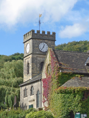
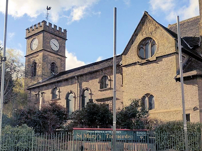
Todmorden St Mary
| |
England
& Wales Hardwicke Marriage Index |
The ParishThe chapelry of Todmorden, its mother parish being Rochdale, lies in the extreme east of Lancashire forming a lengthy stretch of the county's border with neighbouring Yorkshire. Todmorden has always been a border town with its western part in Lancashire and the eastern portion in Yorkshire, finally in 1888 the matter was resolved by transferring Todmorden into Yorkshire leaving it in a separate county from its mother parish, we choose to place it in Lancashire accordingly. Todmorden is located roughly 20 miles northeast of Manchester and sits at the junction of the A646 road which connects Burnley with Halifax and the A6033 which links through to Littleborough and onwards as the A58 to Rochdale. Todmorden sits deep within the valley of the River Calder which markedly impacts the shape of the town, the Calder is closely tracked by the A646 and most properties lie in the valley bottom as a strip of urban development, entering from the south the Mighelden Brook leads to a tale of properties extending south to include Walsden. Prior to the industrial revolution this was a simple upland farming area with cattle grazing in the valleys and sheep on the higher and less fertile moors. The area, however, was found to abound with coal as well as good building stone, couple these assets with power from the swift flowing Calder and Todmorden grew spectacularly during the late 18th and 19th centuries. The Fielden family's cotton business underpinned the local economy growing into one of the nation's largest reputedly spinning 60,000lb of cotton yarn per annum; the yarn supplying many fabric works too manufacturing from the raw material. Today much of that industry has passed into industrial heritage with Todmorden retiring merely to a role as a market town for Upper Calderdale. Modern developments have come aplenty to Todmorden, the Rochdale Canal was completed to link the Calder through to western ports in 1804, this was followed in 1841 by the construction of the Manchester & Leeds Railway line through what was at the time the longest railway tunnel in the world, a link to Burnley was added in 1849 and on to Preston in 1850. Todmorden today is also a centre for access to the gritty moors of the area, it is overlooked by the monument atop Stoodley Pike which is passed by the Pennine Way National Trail, England's first, and the moors are criss-crossed by ancient byways. Todmorden is drained eastwards by the Calder which skirts south of Halifax, Dewsbury and Wakefield before passing out onto the Vale of York where it joins Yorkshire's other Dales rivers to flow into the North Sea through the Humber Estuary. Todmorden is sited at 130 metres above the sea at its church by the Calder, land steeply rises to moorland tops of 420 metres on Blake Moor to the southeast and 454 metres on Freeholds Top to the southwest both within a few miles of the town whilst Black Hameldon at 479 metres represents the local high point to the northwest. Early gazetteers are reticent about the acreage of the chapelry stating merely that it was not separately enumerated from the vast Rochdale parish, suffice it to say the population of Todmorden grew exponentially during the transcript period, the marriages recorded are indicative of an average population across that period of around 3.500 rising to over 10,700 by the end of the period. Todmorden is recorded in Domesday Book under the manor of Stansfield where it is described merely as waste following the reprisals of William the Conqueror for northern based rebellion, the remainder of its entry is a regional listing stretching as far into Yorkshire as Kirkburton. |
 |
|
|
|
| Register No | Covering Dates | Deposited With | Register Style | Quality Standard | Comments |
| 1 |
26th May 1754 - 8th September 1807 |
West Yorkshire Archive Service - Wakefield - Reference -
WDP46/1/3/1 |
Standard preprinted and self-numbered combined Banns &
Marriage register with 4 entries per page |
Grade 2 Register - not a perfect read but with a low
likelihood of misreads |
None |
| 2 | 12th October 1807 - 29th December 1812 | West Yorkshire Archive Service - Wakefield - Reference - WDP46/1/3/2 | Standard preprinted and self-numbered Marriage register with 4 entries per page | Grade 2 Register - not a perfect read but with a low likelihood of
misreads |
None |
| 3 | 11th January 1813 - 6th June 1837 | West Yorkshire Archive Service - Wakefield - Reference - WDP46/1/3/3 | Standard Rose style preprinted and prenumbered Marriage register | Grade 2 Register - not a perfect read but with a low likelihood of
misreads |
None |
|
Newchurch
in Rossendale St Nicholas & St John
Whalley St Mary |
Heptonstall
St Thomas, Yorkshire
Halifax St John, Yorkshire |
Heptonstall
St Thomas, Yorkshire
Halifax St John, Yorkshire |
|
Rochdale
St Chad
|
 |
Halifax
St John, Yorkshire
Ripponden St Bartholomew, Yorkshire |
|
Rochdale
St Chad
|
Rochdale
St Chad
|
Rochdale
St Chad
|
1760 1770 1780 1790 1800 1810 1820 1830
Corrections to Tinstaafl Transcripts