
England
& Wales Hardwicke Marriage Index
Marriages
1754 - 1837
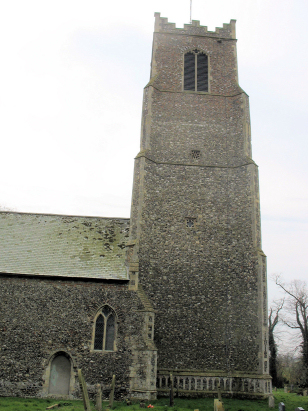
Halvergate St Peter & St Paul
| |
England
& Wales Hardwicke Marriage Index |
The ParishThe parish of Halvergate lies in southeastern Norfolk about 6 miles west of the port of Great Yarmouth. Halvergate is a small and compact village which sits around 2 miles south of the A47 road which connects the city of Norwich with Great Yarmouth. Halvergate was, in Roman times and the early mediaeval period, a seaport, the vast estuary which stretched inland as far as Halvergate having been diminished over the centuries by silting and deliberate man-made draining leaving the village high (relatively) and dry. Halvergate's economy was thus rather mixed for a Norfolk parish, there was, of course, arable farming on higher ground to the west of the village but the extensive grazing marshes provided variation, the close proximity of poorly drained land also enable wildfowling and reed for thatch to be important parts of the economy. Modern developments came to the parish but largely passed it by, the Norwich to Great Yarmouth rail line via Acle passing through the northern edge of the parish. Many manmade channels feed water into the Fleet which makes its way eastwards to Breydon Water and the Yare to reach the sea through Great Yarmouth. Halvergate is sited at around 15 metres above the sea, land is rather flat and plateau-like around here, once off the marshes, and local heights reach little higher for many miles. Halvergate parish was large for Norfolk and contained roughly 2/3rd marshland and reclaimed territory (the reclaimed land was spread amongst neighbouring parishes creating little exclaves of territory for many and complicating the parish maps for this area), covering just over 2,600 acres it would have supported a population of close to 500 parishioners. In Domesday times Halvergate was held directly by King William, a prosperous place of 15 ploughs, a small meadow and a salthouse. |
 |
|
|
|
| Register No | Covering Dates | Deposited With | Register Style | Quality Standard | Comments |
| 1 | 10th May 1755 - 13th October 1766 | Norfolk Record Office - Reference - PD354/1 | Plain, unruled book, a continuation of the extant composite register in contravention of Hardwicke's segregation & wording requirements | Grade 2 Register - not a perfect read but with a low likelihood of misreads | None |
| 2 | 5th January 1768 - 13th February 1812 | Norfolk Record Office - Reference - PD354/4 | Standard preprinted and self-numbered Marriage register with 4 entries per page | Grade 2 Register - not a perfect read but with a low likelihood of misreads | None |
| 3 | 18th January 1813 - 4th January 1837 | Norfolk Record Office - Reference - PD354/5 | Standard Rose style preprinted and prenumbered Marriage register | Grade 2 Register - not a perfect read but with a low likelihood of misreads | None |
|
Burlingham
St Andrew (detached)
Acle St Edmund (detached) South Walsham St Lawrence (detached) |
||
|
Moulton
St Mary
Freethorpe All Saints |
 |
Acle St
Edmund (detached)
Freethorpe All Saints (detached) |
|
Freethorpe
All Saints
|
Freethorpe
All Saints (detached)
Moulton St Mary (detached) Beighton All Saints (detached) |
1760 1770 1780 1790 1800 1810 1820 1830
Corrections to Tinstaafl Transcripts