
England
& Wales Hardwicke Marriage Index
Marriages
1754 - 1837
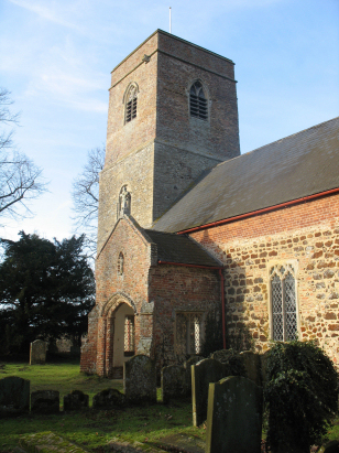
Runcton Holme St James
| |
England
& Wales Hardwicke Marriage Index |
The ParishThe parish of Runcton Holme lies in western Norfolk, in the flatlands of Norfolk's Fens. Runcton Holme is located about 4 miles north of the market town of Downham Market. Runcton Holme is a compact small village built around a crossroads of lanes about a mile west of the A10 road which links Downham Market with the port of King's Lynn. Nowadays this is an intensely arable region, with big open fields of cereals, at the time of this transcript a more mixed farming regime would have applied. Runcton Holme is located close to one of The Fens greatest draining rivers, the Great Ouse, indeed it forms the western boundary of the parish. The Great Ouse heads northwards to reach the sea in The Wash through King's Lynn. Runcton Holme is very low lying, at barely 3 metres above sea level it is quite typical of Norfolk's Fens. Runcton Holme parish is fairly typically sized too, at almost 1,100 acres it would have supported almost 300 parishioners. In Domesday Times the land was held by the Abbey of Bury St Edmunds, it boasted 11 ploughs as well as meadows & woodland, a mill and a fishery making for a wealthy place at that time. |
 |
|
|
|
| Register No | Covering Dates | Deposited With | Register Style | Quality Standard | Comments |
| 1 | 23rd April 1754 - 21st December 1812 | Norfolk Record Office - Reference - PD/501/6 | Standard preprinted and self-numbered Marriage register with 3 entries per page | Grade 2 Register - not a perfect read but with a low likelihood of misreads | None |
| 2 | 25th June 1813 - 20th April 1837 | Norfolk Record Office - Reference - PD/501/7 | Standard Rose style preprinted and prenumbered Marriage register | Grade 2 Register - not a perfect read but with a low likelihood of misreads | None |
|
Wiggenhall
St Mary Magdalen
|
Watlington
St Peter & St Paul
|
Tottenhill
St Botolph
|
|
Wiggenhall
St Mary Magdalen
|
 |
Shouldham
Thorpe The Virgin Mary
|
1760 1770 1780 1790 1800 1810 1820 1830
Corrections to Tinstaafl Transcripts