
England
& Wales Hardwicke Marriage Index
Marriages
1754 - 1837
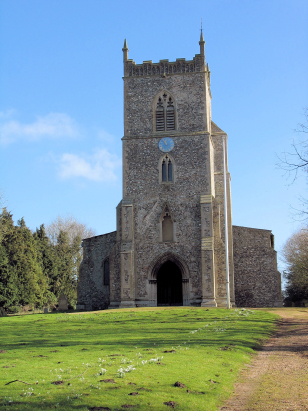
Sporle St Mary
| |
England
& Wales Hardwicke Marriage Index |
The ParishThe parish of Sporle lies towards the western portion of central Norfolk. Sporle is located roughly 2 1/2 miles northeast of the market town of Swaffham and sits a little over a mile north of the A47 road which crosses Norfolk from west to east from King's Lynn to Great Yarmouth. Sporle is a mid-sized and rather linear village mostly sat along a northward leading lane heading towards nearby Castle Acre from the A47, strung along this lane and its immediate side lanes are a long string of the village whilst the wider parish has the usual scatter of farms and cottages. Sporle sits away from the poorer soils of nearby Breckland and its farming is dominated almost entirely by arable farming with early gazetteers placing over 90% of the parish acreage as set to arable farming, today large fields dominate the rounded hills of the parish replete with the harsh yellow hue of oil-seed in many. Sporle sits just over a half mile east of Norfolk's premier hiking track, The Peddars Way, an ancient route the history of which is disputed, passes close by enabling today's hikers to seek respite in Sporle's inn, soon to be reopened as the first to commemorate King Charles III. Modern developments came and went from Sporle, the Midland & Great Northern railway line between Swaffham and East Dereham long since closed and large parts usurped by East Dereham's A47 bypass. Whilst there is little surface drainage around by the village, small streams and field drains make their way northwards to join the infant River Nar, the latter turns westward and eventually meets the Great Ouse within the confines of King's Lynn before heading into The Wash. Sporle is sited at around 60 metres above the sea surrounded by gently undulating land which rises to just over 80 metres before plunging into the Nar valley. Sporle parish, which in early medieval times adsorbed the twin parishes of Palgrave, is large by Norfolk standards, covering almost 4,200 acres it would have supported a population of close to 750 parishioners. In Domesday times Sporle was a wealthy manor retained by King William, himself, offering 19 ploughs together with meadows and woodland it also possessed 6 mills making it a profitable holding indeed. |
 |
|
|
|
| Register No | Covering Dates | Deposited With | Register Style | Quality Standard | Comments |
| 1 | 22nd November 1754 - 19th November 1812 | Norfolk Record Office - Reference - PD709/5 | Standard preprinted and self-numbered combined Banns & Marriage register with 4 entries per page | Grade 2 Register - not a perfect read but with a low likelihood of misreads | None |
| 2 | 3rd February 1813 - 30th March 1837 | Norfolk Record Office - Reference - PD709/6 | Standard Rose style preprinted and prenumbered Marriage register | Grade 2 Register - not a perfect read but with a low likelihood of misreads | None |
|
Southacre
St George
|
||
|
Southacre
St George
Swaffham St Peter & St Paul |
 |
Little
Dunham St Margaret
Necton All Saints |
|
Swaffham
St Peter & St Paul
|
Swaffham
St Peter & St Paul
North Pickenham St Andrew
|
North
Pickenham St Andrew
Holme Hale St Andrew |
1760 1770 1780 1790 1800 1810 1820 1830
Corrections to Tinstaafl Transcripts