
England
& Wales Hardwicke Marriage Index
Marriages
1754 - 1837
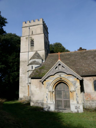
Shirburn All Saints
| |
England
& Wales Hardwicke Marriage Index |
The ParishThe parish of Shirburn lies in southeastern Oxfordshire forming a short stretch of the border with neighbouring Buckinghamshire. Shirburn sits at the foot of the Chiltern Hills some 10 miles northeast of the Thames-side town of Wallingford. Shirburn sits on the B4009 road which runs from close to Wallingford along the base of the Chilterns through almost to the Bedfordshire town of Dunstable. Shirburn is a rather small village with most properties either on the B4009 or the twin short side roads that lead away. Shirburn is an estate village with the land held by the owner's of Shirburn Castle which sits in grounds to the northwest of the B4009. This major country seat was given permission to castellate by King Edward III. The castle, built in the symmetrical quadrangular style of similar French chateau of the 13th century, sits in formal gardens laid out in the early 18th century. Shirburn parish is elongated on a northwest to southeastern axis, the purpose is to encompass a range of land-use types from the thick clays of the Oxford basin through to the high chalk tops of the Chiltern range giving a varied farming regime across these areas. Modern developments have come and departed from Shirburn, a branch railway line, also skirting the base of the Chilterns, has since closed and been largely dismantled, the modern M40 motorway, however, emerges from the Chilterns some 2 miles northeast of Shirburn. Shirburn is drained northwestwards by a small tributary of the River Thame which is met at Stadhampton, the Thames, in turn, meets the Thames and turns back eastwards to pass through the capital to the North Sea. Shirburn is sited at around 110 metres above the sea, a general height for the Oxford Vale, land, however, rises in the chalk escarpment of the Chilterns to the southeast topping out at 255 metres on nearby Shirburn Hill. Covering close to 2,300 acres Shirburn parish was a little larger than most rural southern parishes, within that acreage would have been supported around 350 parishioners. In Domesday times Shirburn was shared between two prominent Normans, Robert d'Oilly & Roger d/Ivry whose assets totalled 13 ploughs as well as extensive meadows, pastures & woodland, their collective population being sufficient to place quiet rural Shirburn amongst the largest 20% of settlements recorded in that book, quite a change from today. |
 |
|
|
|
| Register No | Covering Dates | Deposited With | Register Style | Quality Standard | Comments |
| 1 | 12th May 1754 - 30th August 1812 | Oxfordshire History Centre - Reference -
PAR237/1/R3/1 |
Standard preprinted and self-numbered combined Banns & Marriage register with 4 entries per page | Grade 2 Register - not a perfect read but with a low likelihood of misreads | None |
| 2 | 8th August 1813 - 2nd July 1836 | Oxfordshire History Centre - Reference - PAR237/1/R3/2 | Standard Rose style preprinted and prenumbered Marriage register | Grade 2 Register - not a perfect read but with a low likelihood of misreads | None |
|
South
Weston St Lawrence
|
South
Weston St Lawrence
|
|
|
Pyrton
St Mary
|
 |
|
|
Turville
St Mary, Buckinghamshire
|
Ibstone
St Nicholas
|
1760 1770 1780 1790 1800 1810 1820 1830
Corrections to Tinstaafl Transcripts