
England
& Wales Hardwicke Marriage Index
Marriages
1754 - 1837
St Davids
| |
England
& Wales Hardwicke Marriage Index |
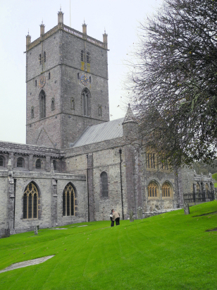
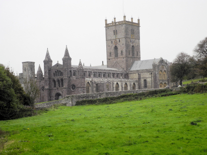
The ParishThe parish of St Davids is the most westerly in Pembrokeshire forming an extensive stretch of its Irish Sea coastline. St Davids is located roughly 16 miles west of the county town of Haverfordwest and sits on the A487 road which forms the coast road around the peninsula on which St Davids is set. St Davids is, of course, of great repute as Britain's smallest cathedral city, smaller in size than many market towns; it forms a rough oval leaning on a southwest to northeast line and centred upon the market place where the A487 performs a tight bend on reverses its course. St Davids is of ancient origins, it is likely that a Celtic settlement existed here as early as the 1st century BC but it is to the 5th century and christian colonisation from Ireland that the site became established. St David is of obscure origins, his birth and death dates hotly disputed, but his religious community, harsh & ascetic by modern standards, grew and prevailed despite periodic destruction; the Welsh Annals record 11 times destruction was wrought only for the site to recover between 906 & 1089. Always a place of pilgrimage, even William the Conqueror came to St Davids as a pilgrim, it remains so today. Today's St Davids attracts pilgrims of a touristic nature, drawn both by the history of the city and also by the splendours of Pembrokeshire's iconic coastline, St Davids is the main base for the area and is often crowded as a consequence. The stunning Pembrokeshire Coastal Trail squirms around headlands and coves passing by St Davids on 3 sides and brings much trade to the city's accommodation providers too. The economy of the parish was a mixture of farming, both arable and pastoral being practiced, together with sea-borne incomes from fishing and coastal transportation of goods, a small port at Porthclais sufficing for the latter. Numerous small streams drain down to the nearby coast forming steeply sided valleys and deeply inset coves. St Davids is sited at between 50 and 60 metres above the sea, the isolated lump of Carn Hen at 181 metres forms the nearest local high point. St Davids parish is one of the widest in extent within its county, covering almost 10,700 acres that would have supported a population of around 2,400 parishioners. Like most of Wales St Davids is not mentioned in Domesday Book which did not cover this area. |
 |
|
|
|
| Register No | Covering Dates | Deposited With | Register Style | Quality Standard | Comments |
| 1 | 4th June 1754 - 17th March 1774 | Pembrokeshire Archives - Reference HPR/144/2 | Standard preprinted and self-numbered Marriage register with 4 entries per page | Grade 2 Register - not a perfect read but with a low likelihood of misreads | None |
| 2 | 2nd May 1774 - 8th November 1788 | Pembrokeshire Archives - Reference HPR/144/3 | Standard preprinted and self-numbered Marriage register with 3 entries per page | Grade 2 Register - not a perfect read but with a low likelihood of misreads | None |
| 3 | 15th November 1788 - 3rd May 1799 | Pembrokeshire Archives - Reference HPR/144/4 | Standard preprinted and self-numbered Marriage register with 3 entries per page | Grade 2 Register - not a perfect read but with a low likelihood of misreads | None |
| 4 | 5th May 1799 - 31st December 1812 | Pembrokeshire Archives - Reference HPR/144/11 | Standard preprinted and self-numbered Marriage register with 3 entries per page | Grade 2 Register - not a perfect read but with a low likelihood of misreads | None |
| 5 | 19th January 1813 - 20th June 1837 | Pembrokeshire Archives - Reference HPR/144/12 | Standard Rose style preprinted and prenumbered Marriage register | Grade 2 Register - not a perfect read but with a low likelihood of misreads | None |
|
|
|
Llanrhian
St Rhian
|
|
|
 |
Llanhowel
St Hywel
Whitchurch St Michael |
|
|
|
Whitchurch
St Michael
|
1760 1770 1780 1790 1800 1810 1820 1830
Corrections to Tinstaafl Transcripts