
England
& Wales Hardwicke Marriage Index
Marriages
1754 - 1837
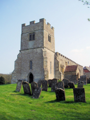
Chesterton St Giles
| |
England
& Wales Hardwicke Marriage Index |
The ParishThe parish of Chesterton lies in southern Warwickshire roughly 5 miles southwest of the market town of Southam. Chesterton sits about a mile east of the B4455 road, which follows the line of the ancient Roman Road of the Fosse Way, which avoids all significant towns before finally meeting Watling Street as it forges a southwest to northeast course through the South Midlands. It is believed, from the "chester" in the name that Chesterton was founded in Roman times as a fort upon the Fosse Way. The village is unusual in having been considerably bigger than it is today, a mere scatter of farms and cottages with no real centre. The whole area is pocked with remains of its former status as a town with the mansion of the Peto family at its heart, all now disappeared save for sub-surface archaeology. Chesterton's extensive parish would largely have been used as a mixture of pastures and woodland all residing upon a clay substrate. Modern developments have come to the parish, the modern M40 motorway cuts through the area en route between Birmingham and Oxford but has no exit for Chesterton merely a roadside services. Chesterton has rather vague drainage which trends westwards as small intermittent brooks eventually consolidating into Thelsford Brook which feeds the Avon, the latter heads further westwards to meet the Severn which turns water south to the sea through the Bristol Channel. Chesterton is sited on rising ground with the Roman town on Fosse Way at 70 metres whilst the parish church is some 20 metres higher, southeastwards land gently rises to 125 metres above the sea on Christmas Hill near Bishops Itchington. As already mentioned Chesterton parish was extensive covering almost 3,600 acres and its much diminished population of close to 200 parishioners would have been supported. In Domesday time Chesterton recorded 55 households which is probably more than exist today and certainly large enough to place it into the top 20% of settlements by population, shared between 4 landholders it offered an impressive 20 ploughs backed by a series of small meadows. |
 |
|
|
|
| Register No | Covering Dates | Deposited With | Register Style | Quality Standard | Comments |
| 1 |
21st November 1754 - 16th September 1781 |
Warwickshire County Record Office - Reference - DR0031/2a |
Plain, ruled book containing Marriages |
Grade 3 Register - there are sufficient quality issues
with this register to indicate that some misreads will occur
albeit few in number |
2 entries are faded to oblivion on page 2, pure guess made NB this register is bound together with its successor into a single archival deposit |
| 2 | 11th February 1782 30th December 1812 | Warwickshire County Record Office - Reference - DR0031/2b | Standard preprinted and self-numbered Marriage register with 3 entries per page | Grade 2 Register - not a perfect read but with a low likelihood of
misreads |
None NB this register is bound together with its predecessor into a single archival deposit |
| 3 | 24th June 1813 - 31st October 1836 | Warwickshire County Record Office - Reference - DR0031/4 | Standard Rose style preprinted and prenumbered Marriage register | Grade 2 Register - not a perfect read but with a low likelihood of misreads | None |
|
Bishops
Tachbrook St Chad
|
Harbury
All Saints
|
Harbury
All Saints
|
|
Bishops
Tachbrook St Chad
Newbold Pacey St George Lighthorne St Lawrence |
 |
Bishops
Itchington St Michael
|
|
Lighthorne
St Lawrence
|
Lighthorne
St Lawrence
Gaydon St Giles |
Bishops
Itchington St Michael
|
1760 1770 1780 1790 1800 1810 1820 1830
Corrections to Tinstaafl Transcripts