
England
& Wales Hardwicke Marriage Index
Marriages
1754 - 1837
Knowle St John the
Baptist, St Lawrence & St Anne
| |
England
& Wales Hardwicke Marriage Index |
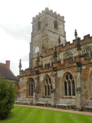
The ParishThe parish of Knowle lies in western Warwickshire not too far from its border with neighbouring Worcestershire. Knowle is sited roughly equidistant from the city of Birmingham and from Warwick being 10 miles southeast of the former and 10 northwest of the latter. Knowle sits on the A4141 which links Solihull through to Warwick. Until the late 17th century Knowle was a mere chapelry of the then vast Hampton in Arden parish before becoming one in its own right. Knowle is a much expanded village in modern times, early maps show a mid-sized crossroads settlement with an oval of lanes holding most properties together with a eastwards running extension towards the Grand Union Canal. This former road pattern is still discernible in today's layout but Knowle has expanded towards Birmingham engulfing Copt Heath, to the west incorporating both Tilehouse Green and Dorridge into a broad expanse of urban development of small town size. At the time of this transcript Knowle would have been a mere farming parish with roughly equal parts of arable and pastoral methods, today it also functions as a dormitory suburb for both Birmingham and Warwick. Modern developments have come aplenty, the aforementioned Grand Union Canal, linking Birmingham with London, arrived first followed by the Birmingham to Warwick railway line granting Dorridge a station whilst today's modern M42 motorway carves its way through the area to the west of Knowle. Knowle is drained northwards by the River Blythe which joins in turn the Tame and Trent on their long journey to reach the North Sea arriving through the Humber Estuary. Knowle received it name because it does just that, it sits on a knoll at around 120 metres above the sea land does, however continue to rise southwest to reach 140 metres where M42 meets M40. The parish of Knowle is one of the more extensive in its county, covering almost 3,300 acres within which it would have supported a population of around 1,200 parishioners. Knowle, itself, is not, however, mentioned in Domesday Book but the manor of Longdon sitting just southwest of Copt Heath is so mentioned, it was held by one Thorkil of Warwick, presumably a Saxon survivor, and was poor in assets with just 2 ploughs backed by the usual meadows & woodland. |
 |
|
|
|
| Register No | Covering Dates | Deposited With | Register Style | Quality Standard | Comments |
| 1 | 6th July 1754 - 15th November 1812 | Warwickshire County Record Office - Reference -
DRB0056/7 |
Standard preprinted and self-numbered Marriage register with 4 entries per page | Grade 3 Register - there are sufficient quality issues with this register to indicate that some misreads will occur albeit few in number | This register suffers both from fading and also from poor handwriting making it possible that one or two misreads will have occurred |
| 2 | 4th October 1813 - 20th March 1837 | Warwickshire County Record Office - Reference - DRB0056/8 | Standard Rose style preprinted and prenumbered Marriage register | Grade 2 Register - not a perfect read but with a low likelihood of misreads | None |
|
Solihull
St Alphege
|
Barston
St Swithin
|
Barston
St Swithin
|
 |
Hampton
in Arden St Mary & St Bartholomew (detached)
|
|
|
Bearley
St Mary
|
1760 1770 1780 1790 1800 1810 1820 1830
Corrections to Tinstaafl Transcripts