
England
& Wales Hardwicke Marriage Index
Marriages
1754 - 1837
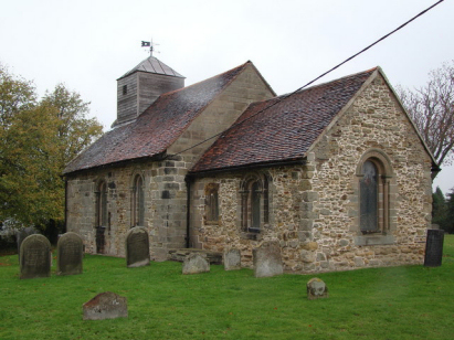
Shuttington St Matthew
| |
England
& Wales Hardwicke Marriage Index |
The ParishThe parish of Shuttington lies in the extreme north of Warwickshire forming a lengthy stretch of the county's border with neighbouring Staffordshire. Shuttington is located roughly 3 miles east of the Staffordshire town of Tamworth and sits about 2 miles south of the B5493 road which links Tamworth with the M42 motorway. Shuttington is a small and compact village formed around a triangular junction of lanes on the northern edge of the flood-plain of the River Anker. Like many Midlands parishes it would have been farmed using a mixture of both arable and pastoral methods, early gazetteers here estimate in roughly equal proportions. A feature of the parish today is the consequence of mining, subsidence from deep coal workings has created a series of flooded pits, similar to those formed by gravel workings, in the Anker's valley which have become havens for wildlife. Modern developments abound around the village, the first to arrive was the Coventry Canal which takes advantage of the Anker's valley to pass through, the railway line from Tamworth to Nuneaton soon followed and today the modern M42 motorway carves its way northeast through the east of the parish. Shuttington is drained westwards by the Anker which soon meets the Tame in Tamworth, water then turns north to reach the Trent and joins that mighty river for the long journey to the North Sea arriving through the Humber Estuary. Shuttington is sited at around 80 metres above the sea, a similar height extends for some distance broken only by the isolated knoll to the west of nearby Warton which climbs to 114 metres. By Warwickshire standards Shuttington parish was towards the smaller end of the scale covering just under 1,400 acres it would have supported a population of close to 200 parishioners. In Domesday times Shuttington was also a modest rural manor held y the Count of Meulan it offered 5 ploughs backed by meadows and some extensive woodland it also came with a mill. |
 |
|
|
|
| Register No | Covering Dates | Deposited With | Register Style | Quality Standard | Comments |
| 1 |
25th October 1757 - 19th December 1812 |
Warwickshire County Record Office - Reference - DRB007/3 |
Standard preprinted and self-numbered combined Banns &
Marriage register with 4 entries per page |
Grade 2 Register - not a perfect read but with a low
likelihood of misreads |
None |
| 2 | 25th August 1813 - 15th February 1837 | Warwickshire County Record Office - Reference - DRB007/4 | Standard Rose style preprinted and prenumbered Marriage register | Grade 2 Register - not a perfect read but with a low likelihood of misreads | None |
|
Tamworth
St Editha, Staffordshire
|
Clifton
Campville St Andrew, Staffordshire
|
Thorpe
Constantine St Constantine, Staffordshire
Seckington All Saints |
|
Tamworth
St Editha, Staffordshire
|
 |
Seckington
All Saints
Newton Regis St Mary Polesworth St Editha |
|
Tamworth
St Editha, Staffordshire
|
Polesworth
St Editha
|
Polesworth
St Editha
|
1760 1770 1780 1790 1800 1810 1820 1830
Corrections to Tinstaafl Transcripts