
England
& Wales Hardwicke Marriage Index
Marriages
1754 - 1837
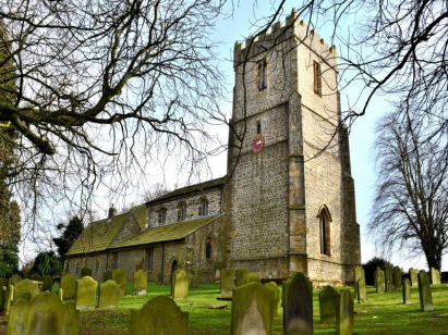
Kirby Ravensworth St Peter & St Felix
| |
England
& Wales Hardwicke Marriage Index |
The ParishThe parish of Kirby Ravensworth, often rendered Kirkby but we follow the modern Ordnance Survey in removing the "k" from Kirby Hill, lies in the far north of Yorkshire not too far from its border with County Durham. The parish name comes from a concatenation of its two principal settlements, Kirby Hill, which has the church, and Ravensworth, the larger of the two settlements. Ravensworth is located about 5 miles northwest of the market town of Richmond, Kirby Hill being a mile south of Ravensworth, and sits a mile south of the A66 Trans-Pennine road linking the A1 through to the A6 & M6 at Penrith. A extensive parish which included the easternmost ranges of the Pennines, it woulld have had a varied economy, farming in the main with arable in the lower parts ranging through cattle pastures upwards to rough moorland grazing dominated by sheep; in addition there was extensive quarrying of the local freestone and for a time a copper mine, ultimately uneconomic, was worked. The Holm Beck, later renamed to Gilling Beck, drains the parish southeastwards joining the Swale to the east of Richmond, thence down through Yorkshire to reach the North Sea through the Humber Estuary. Ravensworth is sited at around 120 metres above the sea, Kirby Hill, as its name suggests, sits on a sharp rise in land at close to 210 metres and land continues to rise southwestwards on to the Pennine Moors topping out at 385 metres on Gayles Moor. Kirby Ravensworth parish was one of the most extensive in the country, typical of an upland and northern parish, it covered close to 14,000 acres and betwee its main settlements and many farms would have supported a population of a little over 1,400 parishioners. Unusually, being so far north, Ravensworth is mentioned in Domesday Book as held by Count Alan of Brittany, a relatively minor place offering just 8 ploughs with a small meadow. |
 |
|
|
|
| Register No | Covering Dates | Deposited With | Register Style | Quality Standard | Comments |
| 1 | 16th April 1754 - 15th November 1772 | North Yorkshire Record Office - Reference PR/KRR/1/4 | Plain, ruled and margined book containing Marriages segregated from Banns | Grade 1 register - few issues noted and a low likelihood of misreads | None |
| 2 | 22nd November 1772 - 15th July 1783 | North Yorkshire Record Office - Reference PR/KRR/1/5 | Plain, unruled book containing Marriages segregated from Banns | Grade 1 register - few issues noted and a low likelihood of misreads | None |
| 3 | 25th November 1783 - 5th October 1810 | North Yorkshire Record Office - Reference PR/KRR/1/6 | Standard preprinted and self-numbered Marriage register with 4 entries per page | Grade 2 register - not a perfect read but with a low likelihood of misreads | None |
| 4 | 22nd March 1813 - 12th June 1837 | North Yorkshire Record Office - Reference PR/KRR/1/9 | Standard Rose style preprinted and prenumbered Marriage register | Grade 1 register - few issues noted and a low likelihood of misreads | None |
|
Barningham
St Michael
|
Barningham
St Michael
Wycliffe St Mary |
Hutton
Magna St Mary
|
|
Barningham
St Michael
|
 |
Gilling
West St Agatha
|
|
Arkengarthdale
St Mary
|
Marske
St Edmund
|
Easby
St Agatha
Richmond St Mary |
1760 1770 1780 1790 1800 1810 1820 1830
Corrections to Tinstaafl Transcripts