
England
& Wales Hardwicke Marriage Index
Marriages
1754 - 1837
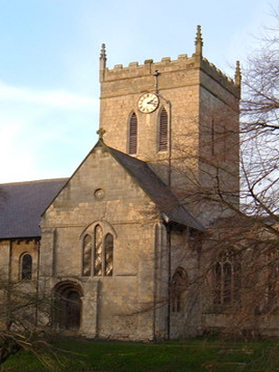
North Newbald St Nicholas
| |
England
& Wales Hardwicke Marriage Index |
The ParishThe parish of North Newbald, which includes the former parish of South Newbald, lies in southern Yorkshire, not too far north of the Humber Estuary and thus its border with Lincolnshire. Newbald, as the two settlements are more commonly known today, is located roughly 4 miles south of the market town of Market Weighton and sits immediately east of the A1034 which links Market Weighton through to the busy A63 at South Cave. Newbald sits on the western edges of the Yorkshire Wolds hills, it consists still of two distinct entities albeit the pair are slowly being connected by properties along the lane linking them, North Newbald, the larger of the two has properties lining the three wings of lanes that meet at a large rectangular village green which still holds the base of the ancient market cross, Newbald having once been a small market town in its own right. The wider parish is farming country and whilst today it is largely typically arable once sheep would have grazed the Wolds' slopes too. The hills are formed from Jurassic limestone and it makes a fine building stone, as in the church, consequently there are many working quarries exploiting this asset. A small stream drains off the Wolds through Newbald and eventually, heading southwards, becomes the Mill Beck, it eventually reaches the inner Humber Estuary and the North Sea. Newbald is sited at between 40 & 50 metres above the sea, the Wolds rising to the east, however, soon rise to a local high spot at 162 metres within a couple of miles, the Yorkshire Wolds Way hiking trail, utilising the heights neglects to enter Newbald, passing through the parish to the east. Newbald parish was extremely extensive for a largely lowland parish, covering a little over 5,700 acres when combined, within that acreage a population of just under 1,000 parishioners would have been supported. In Domesday times Newbald, recorded even then as a single entity, was a tiny place of just 8 households, held by the Archbishop of York its assets were a mere 4 ploughs, albeit potential for a further 12 was recognised, its greatest asset were its 4 mills. |
 |
|
|
|
| Register No | Covering Dates | Deposited With | Register Style | Quality Standard | Comments |
| 1 |
28th July 1754 - 16th January 1790 |
East Riding Archives - Beverley - Reference - PE102/7 |
Standard preprinted and self-numbered combined Banns &
Marriage register with 4 entries per page |
Grade 2 Register - not a perfect read but with a low
likelihood of misreads |
None |
| 2 | 4th February 1790 - 12th December 1812 | East Riding Archives - Beverley - Reference - PE102/8 | Standard preprinted and self-numbered Marriage register with 4 entries per page | Grade 2 Register - not a perfect read but with a low likelihood of
misreads |
None |
| 3 | 28th April 1813 - 15th August 1836 | East Riding Archives - Beverley - Reference - PE102/9 | Standard Rose style preprinted and prenumbered Marriage register | Grade 2 Register - not a perfect read but with a low likelihood of
misreads |
None |
|
Sancton
All Saints
|
Sancton
All Saints
|
Cherry
Burton St Michael
|
|
Sancton
All Saints
North Cave All Saints (detached) Hotham St Oswald |
 |
Bishop
Burton All Saints
Walkington All Hallows |
|
Hotham
St Oswald
|
North
Cave All Saints
|
Rowley
St Peter
|
1760 1770 1780 1790 1800 1810 1820 1830
Corrections to Tinstaafl Transcripts