
England
& Wales Hardwicke Marriage Index
Marriages
1754 - 1837
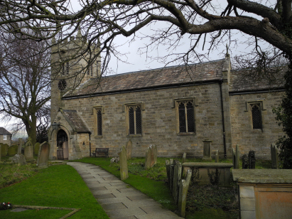
West Witton St Bartholomew
| |
England
& Wales Hardwicke Marriage Index |
The ParishThe parish of West Witton lies in northwestern Yorkshire within the North Riding and roughly 4 miles southwest of the small town of Leyburn. West Witton sits on the A684 road which links Leyburn across the Pennines to Sedbergh. West Witton is a linear village with most properties lining the A684 for just under a half mile, it sits in Wensleydale tucked tight below high moorland close by to its south which constrains the village in that direction, to the north a shelf of more gentle terrain leads down to the River Ure. Like most parishes in the northern Yorkshire Dales the economy was based upon a mixture of the extractive industries, now closed, and upland low-intensity farming of a pastoral nature. The higher parts of the parish being the domain of sheep whilst the lusher pastures close to the Ure held cattle. Today it is outdoor pursuits which drive the economy with short-stay tourism the mainstay, there are numerous hiking trails, the Ure for fishing and the moorland road present a challenge to both on-road and off-road cyclists. West Witton is drained eastwards by the Ure, Wensleydale being the only dale not named after its river, once out of the hill-country it turns more southwards, passing east of Ripon meeting in turn the Swale, Ouse and Nidd to pass through York and reach the North Sea through the Humber Estuary. West Witton is sited on rising ground, the east of the village at 180 metres, the west at 200, to the south West Witton Moor rises to around 400 metres within a half mile but higher ground to the south on Melmerby Moor tops out at 551 metres at the Height of Hazely, the highest point around. Like most upland parishes much land was needed to support a viable population, roughly 5,100 acres constituted West Witton parish which would have supported a population of close to 500 parishioners. In Domesday time West Witton was recovering from the "harrowing of the north", held by Count Alan of Brittany it could muster 7 ploughs, with potential for 11 more, backed by extensive meadows. |
 |
|
|
|
| Register No | Covering Dates | Deposited With | Register Style | Quality Standard | Comments |
| 1 |
24th September 1755 - 26th November 1812 |
North Yorkshire Record Office - Reference - PR/WIW/1/5 |
Plain, ruled & margined book containing Marriages |
Grade 2 Register - not a perfect read but with a low
likelihood of misreads |
None |
| 2 | 22nd February 1813 - 1st June 1837 | North Yorkshire Record Office - Reference - PR/WIW/1/7 | Standard Rose style preprinted and prenumbered Marriage register | Grade 2 Register - not a perfect read but with a low likelihood of
misreads |
None |
|
Aysgarth
St Andrew
|
Bolton
cum Redmire St Oswald
Wensley Holy Trinity |
Wensley
Holy Trinity
|
|
Aysgarth
St Andrew
|
 |
Wensley
Holy Trinity
|
|
Aysgarth
St Andrew
|
1760 1770 1780 1790 1800 1810 1820 1830
Corrections to Tinstaafl Transcripts