
England
& Wales Hardwicke Marriage Index
Marriages
1754 - 1837
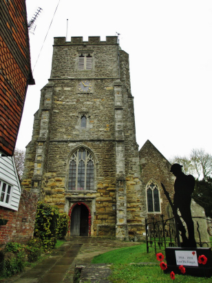
Staplehurst All Saints
| |
England
& Wales Hardwicke Marriage Index |
The ParishThe parish of Staplehurst lies in southern Kent within the heart of The Weald and roughly 9 miles south of the county town of Maidstone. Staplehurst sits on the A229 road which links Maidstone through to Hawkhurst and eventually the A21 (London to Hastings) road, the A229 through the village sits upon the ancient Roman road which crossed The Weald. At the time of this transcript Staplehurst was a mid-sized village atop a low limestone ridge, a sizeable settlement sufficiently large enough to hold an annual fair for the local crops of cattle, corn & hops. Sitting within the Weald the soils hereabouts are rather poor, the above produce reflecting the farming economy of the area, in addition the substantial forests within The Weald were extensively managed for both timber and coppice. Staplehurst saw extensive growth following the arrival of the railway line connecting Ashford through Staplehurst to Tonbridge and the main routes to the capital, this connection made Staplehurst an attractive commuter settlement and lead the village to steadily grow northwards to meet the railway line at its station, the result is a largely linear village stretching almost a mile and a half along either side of the A229. Staplehurst is drained northwestwards by the River Boult, this river meets the Medway south of Yalding and the latter passes through Maidstone to reach the outer Thames Estuary through the port of Chatham. Staplehurst is sited at between 20, at the station, and 40 metres, at the church, above the sea, that 41 metre spot height represents the highest ground within The Weald for some distance. Staplehurst parish was one of the most extensive within its county, a feature of Wealden parishes and reflecting the poor quality of the land, it acreage at a little over 5,700 acres being more reminiscent of an upland parish, nevertheless would have supported a population of almost 1,600 parishioners. The Weald is sparsely represented in Domesday Book, an undeveloped area and covered largely by Royal hunting forests, consequently like so many parishes in the area Staplehurst is not mentioned in that book. |
 |
|
|
|
| Register No | Covering Dates | Deposited With | Register Style | Quality Standard | Comments |
| 1 | 20th July 1754 - 1st November 1809 | Kent History & Library Centre - Maidstone- Reference - P347/1/A/5 | Standard preprinted and self-numbered Marriage register with 4 entries per page | Grade 1 Register - Few issues noted and a low likelihood of misreads | None |
| 2 | 24th November 1809 - 25th December 1812 | Kent History & Library Centre - Maidstone- Reference - P347/1/D/1 | Standard preprinted and self-numbered Marriage register with 4 entries per page | Grade 1 Register - Few issues noted and a low likelihood of misreads | None |
| 3 | 4th January 1813 - 31st May 1837 | Kent History & Library Centre - Maidstone- Reference - P347/1/D/2 | Standard Rose style preprinted and prenumbered Marriage register | Grade 2 Register - not a perfect read but with a low likelihood of misreads | None |
|
Marden
St Michael & All Angels
|
Headcorn
St Peter & St Paul
|
|
|
Marden
St Michael & All Angels
|
 |
Headcorn
St Peter & St Paul
Frittenden St Mary |
|
Cranbrook
St Dunstan
|
Frittenden
St Mary
|
1760 1770 1780 1790 1800 1810 1820 1830
Corrections to Tinstaafl Transcripts