
England
& Wales Hardwicke Marriage Index
Marriages
1754 - 1837
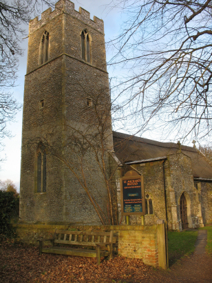
Irstead St Michael
| |
England
& Wales Hardwicke Marriage Index |
The ParishThe parish of Irstead lies in eastern Norfolk about 3 miles south of the small market town of Stalham. Irstead is a rather small village, lacking most amenities, sitting on the western banks of the River Ant where it leaves Barton Broad. Irstead is located about 2 miles east of the A1151 which connects Wroxham with Stalham and is accessed by its own dead-end lane, this is quite an isolated community for Norfolk. Irstead's economy would have been based around agriculture but good farmland was only a small proportion of the area of the parish, much was marshland and indeed Barton Broad. This watery location lead to employment in wildfowling, reed collection and transport along the navigable waters of Norfolk's Broadland. The Ant drains the parish southwards, soon joining the Bure and reaching the North Sea through the Yare and the port of Great Yarmouth. Irstead is sited at just 3 metres above the sea and the land is flat and watery for some distance, local heights to only just above 10 metres. Irstead parish was a typically small Norfolk Broadland parish, it covered just over 1,000 acres but 120 of these was occupied by its share of Barton Broad, it would, however, have supported a population of around 150 parishioners. There is no specific mention of Irstead in Domesday Book. |
 |
|
|
|
| Register No | Covering Dates | Deposited With | Register Style | Quality Standard | Comments |
| 1 | 16th April 1756 - 1st October 1811 | Norfolk Record Office - Reference - PD245/5 | Standard preprinted and self-numbered Marriage register with 3 entries per page | Grade 2 Register - not a perfect read but with a low likelihood of misreads | None |
| 2 | 5th July 1813 - 25th March 1837 | Norfolk Record Office - Reference - PD245/7 | Standard Rose style preprinted and prenumbered Marriage register | Grade 3 Register - there are sufficient quality issues with this register to indicate that some misreads will occur albeit few in number | Fading and spilt ink stains raise the possibility of a few misreads |
|
Barton
Turf St Michael & All Angels
|
Barton
Turf St Michael & All Angels
|
|
|
Neatishead
St Peter
|
 |
|
|
Horning
St Benedict
|
Horning
St Benedict
Ludham St Catherine |
Ludham
St Catherine
|
1760 1770 1780 1790 1800 1810 1820 1830
Corrections to Tinstaafl Transcripts