
England
& Wales Hardwicke Marriage Index
Marriages
1754 - 1837
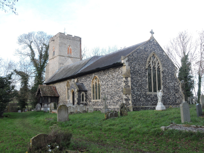
Semer All Saints
| |
England
& Wales Hardwicke Marriage Index |
The ParishThe parish of Semer lies in southwestern Suffolk roughly 3 miles northwest of the market town of Hadleigh. Semer sits about a half mile east of the A1141 road which links Hadleigh with Lavenham. Semer is a rather small village sitting between the A1141 and the B1115 (which runs to Stowmarket) wth most properties lying along the latter road but with no real concentration, the wider parish is dotted with farms and cottages. The River Brett effectively forms the northern limit of the village. The Brett would have given Semer some variation in its farming regime, some pastures & meadows to accommodate cattle and compliment the typical arable nature of the area. Semer is drained southeastwards by the Brett which passes through Hadleigh turns southerly and meets the Stour near Stratford St Mary, the Stour takes water east to the estuary which sits between the twin ports of Felixtowe and Harwich to reach the North Sea. Semer is sited at around 30 metres above the sea in its valley setting, away from the Brett land rises to a spot height of 68 metres midway between Semer and Monks Eleigh on the A1141 in gently undulating terrain. This area of Suffolk has many relatively small parishes and Semer was one of those, covering a little over 1,200 acres it would have supported a population of close to 350 parishioners. In Domesday times Semer was a holding of Bury St Edmunds Abbey and equally small and rural, it offered 6 ploughs, some meadows and a mill. |
 |
|
|
|
| Register No | Covering Dates | Deposited With | Register Style | Quality Standard | Comments |
| 1 |
13th January 1755 - 25th December 1812 |
Suffolk Record Office - Reference - FB85/D1/3 |
Standard preprinted and self-numbered Marriage register
with 4 entries per page |
Grade 2 Register - not a perfect read but with a low
likelihood of misreads |
None |
| 2 | 5th May 1813 - 17th December 1835 | Suffolk Record Office - Reference - FB85/D1/4 | Standard Rose style preprinted and prenumbered Marriage register | Grade 2 Register - not a perfect read but with a low likelihood of misreads | None |
|
Chelsworth
All Saints
|
Chelsworth
All Saints
Nedging St Mary |
Nedging
St Mary
|
 |
||
|
Kersey
St Mary
|
Kersey
St Mary
|
1760 1770 1780 1790 1800 1810 1820 1830
Corrections to Tinstaafl Transcripts