
England
& Wales Hardwicke Marriage Index
Marriages
1754 - 1837
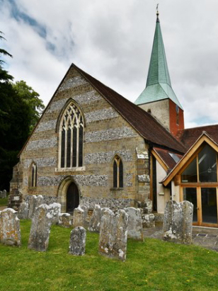
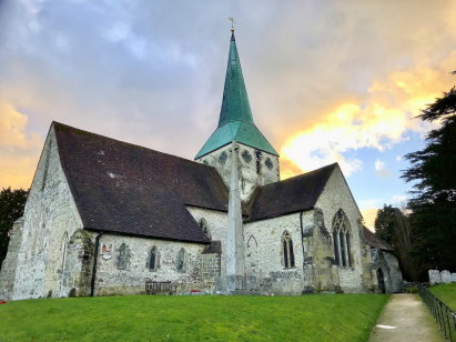
Harting St Mary & St Gabriel
| |
England
& Wales Hardwicke Marriage Index |
The ParishThe parish of Harting lies in the extreme west of Sussex forming an extensive stretch of the border with neighbouring Hampshire. Harting, which actually has 3 villages, West, East & South Harting, lies roughly 4 miles southeast of the market town of \Petersfield and sits at the foot of the escarpment of the South Downs. South Harting, the main village and home for the church, sits on the B2146 road which links Petersfield through to Bosham whilst East Harting sits a mile to its east and West Harting also a mile away but almost north. South Harting is a mid-sized village largely constructed around an oval of roads for which the B2146 forms the western arm, East Harting again sits around an oval of lanes but is much smaller whilst West Harting, as Pevsner suggests is merely a straggle of cottages. Harting sits within the Weald, an area of relatively infertile land between the twin lines of chalk that form North & South Downs, its economy would have been fairly mixed with early gazetteers estimating roughly equal acreages of arable and pastoral methods. In addition the poor soils had left some 15% of the acreage as described as "waste", the area would be dominated by heath & forest and used in common for bracken, coppicing and informal grazing of, mainly, sheep. Modern developments scarcely grazed the northern extremes of the parish, a branch railway line running from Petersfield to Midhurst being closed and largely dismantled. Small streams drain the parish northwards to eet the west to east running River Rother, the Rother eventually crosses a gap in the wall of chalk to reach the English Channel through the port of Littlehampton. South Harting sits at around 65 metres above the sea with its satellite villages some 20 metres higher, looming to the south, however, is the line of Chalk Downs which reaches 242 metres on the top of Beacon Hill, the crest being followed by the South Downs Way National Trail. Harting parish was one of the larger in its county, a feature of Wealden parishes generally, covering close to 7,800 acres it was more reminiscent of a northern upland parish, within that acreage there would have been supported a population of around 1,250 parishioners. The entry of the Hartings in Domesday Book seems scarcely credible, placing it amongst the top 20% of settlements recorded and held by Ear Roger of Shrewsbury it claims that there were an incredible 64 ploughs, the usual meadows & woodland and no fewer than 9 mills, the entry is felt more likely to relate to a district rather than a single, albeit large, manor. |
 |
|
|
|
| Register No | Covering Dates | Deposited With | Register Style | Quality Standard | Comments |
| 1 |
4th October 1754 - 24th December 1812 |
West Sussex Record Office - Reference - Par98/1/1/4 |
Standard preprinted and self-numbered combined Banns &
Marriage register with 4 entries per page |
Grade 2 Register - not a perfect read but with a low
likelihood of misreads |
None NB This register has a printing deficiency - only the right-hand folio being pre-printed with the marriage grid. |
| 2 | 11th January 1813 - 4th April 1837 | West Sussex Record Office - Reference - Par98/1/3/1 | Standard Rose style preprinted and prenumbered Marriage register | Grade 3 Register - there are sufficient quality issues with this
register to indicate that some misreads will occur albeit few in
number |
Fading of this register may result in one or two misreads |
|
Petersfield
St Peter, Hampshire
|
Rogate
St Bartholomew
|
Trotton
St George
|
|
Buriton
St Mary, Hampshire
|
 |
|
1760 1770 1780 1790 1800 1810 1820 1830
Corrections to Tinstaafl Transcripts