
England
& Wales Hardwicke Marriage Index
Marriages
1754 - 1837
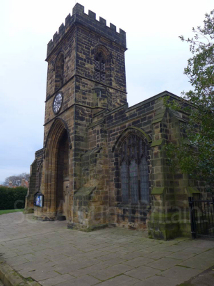
Guisborough St Nicholas
| |
England
& Wales Hardwicke Marriage Index |
The ParishThe parish of Guisborough lies in the extreme northeast of Yorkshire within the district known as Cleveland and not too far from it North Sea coastline. Guisborough is located roughly 9 miles southeast of the industrial town of Middlesborough and sits on the former route of the A171 road (which now bypasses to the north) which connects Middlesborough through to Whitby. Guisborough is a market town, the market being granted by Henry III in 1263, which forms the regional centre for much of the area north of the North York Moors. Guisborough has its origins immediately post the Norman Conquest when an Augustinian Priory was founded here about 1120, the priory church formed one side of the weekly market that made Guisborough wealthy. As well as providing a market for the region's produce Guisborough would have held the specialist trades that could not be supported by small villages. Industry was not a marked component of the economy although exploitation of the local alum was a local speciality. Modern developments have come and gone from Guisborough, a branch railway line linking in to Middlesborough has since been closed. Guisborough does remain a prosperous market town and expansion westwards has seen it grow until it covers well over two miles from west to east with modern estate developments almost butting up to the escarpment that forms the northern edge of the Moors. Guisborough is drained northeastwards by the Skelton Beck which carves its way through steep sided valley to reach the North Sea through nearby Saltburn. Guisborough is sited at around 100 metres above the sea with its southern edges a further 10 metres higher, land rises steeply onto the Moors immediately south rising to 324 metres on nearby Guisborough Moor. Guisborough parish was broad in extent, covering almost 11,900 acres of which 25% consisted of rough moorland, usable only for hardy local sheep, within that extensive acreage a population of just over 2,000 parishioners would have been supported of whom 90% were within the town itself. In Domesday times Guisborough was on the northern edge of the area covered by the book, held by 4 landholders, including the King, himself, its assets were more of potential rather than reality, just 8 ploughs were recorded but with potential for up to 50 and there were meadows and a mill. |
 |
|
|
|
| Register No | Covering Dates | Deposited With | Register Style | Quality Standard | Comments |
| 1 |
9th July 1754 - 12th October 1780 |
Teesside Archives - Reference - PR/GU/2/1/6 |
Standard preprinted and self-numbered combined Banns &
Marriage register with 4 entries per page |
Grade 2 Register - not a perfect read but with a low
likelihood of misreads |
None |
| 2 | 1st November 1780 - 17th October 1812 | Teesside Archives - Reference - PR/GU/2/1/7 | Plain, unruled book containing combined Banns & Marriages | Grade 2 Register - not a perfect read but with a low likelihood of
misreads |
None |
| 3 | 24th February 1813 - 15th June 1837 | Teesside Archives - Reference - PR/GU/2/1/8 | Standard Rose style preprinted and prenumbered Marriage register | Grade 2 Register - not a perfect read but with a low likelihood of
misreads |
None |
|
Eston
St Helen
|
||
|
Ormesby
St Cuthbert
|
 |
Skelton
in Cleveland All Saints
|
|
Kildale
St Cuthbert
Westerdale Christ Church |
Danby
St Hilda
|
1760 1770 1780 1790 1800 1810 1820 1830
Corrections to Tinstaafl Transcripts