
England
& Wales Hardwicke Marriage Index
Marriages
1754 - 1837
Wharram Percy St Martin
| |
England
& Wales Hardwicke Marriage Index |
The ParishThe parish of Wharram Percy lies in eastern central Yorkshire, within the East Riding and roughly 7 miles southeast of the market town of Malton. Wharram Percy is the "text-book" medieval deserted village, a once abandoned site that has been extensively excavated as an example of sites abandoned as a result of the "Black Death" and its impact on populations. Wharram Percy sits in the Yorkshire Wolds about a mile west of the B1248 road which links Old &New Malton through to Beverley, it sits deep within one of the characteristic valleys of the area, often dry on their porous chalk strata. The underlying geology certainly influenced the abandonment, it being poor quality arable soil, thin and lacking mineral depth, but its final demise was more the result of landlord pressure than agricultural failing, the final residents being evicted in c1500 and the land given over to sheep farming. A brief renaissance followed in Victorian times when the chalk was exploited and the modern development of the branch railway line connecting the Maltons with Great Driffield was laid through the valley, this line closed in 1958 and has largely been dismantled, part, however, has reopened as a heritage steam line. The site of Wharram Percy is something of a local tourist attraction, visitors wandering through the bumps and lumps of the former village, it is also visited by hikers following the Wolds Way National Trail. The valleys of the Wolds are often dry but that at Wharram Percy has a perennial stream which drains northwards, merging with others to become the Menethorpe Beck, just before joining the River Derwent; the Derwent heads back south, joining with the Dales' sourced Yorkshire rivers to reach the North Sea through the Humber Estuary. Wharram Percy is sited, within its dale, at around 140 metres above the sea, land outside that dale is largely broad rounded chalk downs rising to 225 metres on the local high spot of Birdsll Brow. Wharram Percy was an extensive parish of almost 8,500 acres its population, mostly scattered away from the row of cottages within the dale, amounted to roughly 350 parishioners during the period of this transcript. In Domesday times the area was largely held by King William and as under-exploited land is described merely as waste. |
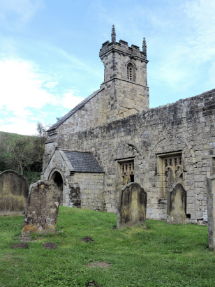 |
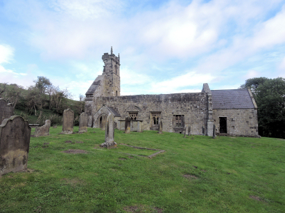
St
Martin's church sits deep in the dale amongst the excavations of
the former village, it is largely ruinous itself. If the extensive
excavations of the medieval village have explained much then the
same process at St Martin's church have probably made it the most
well-known and explained medieval church in the land. The ruined
church and its churchyard were excavated between 1962 & 1974
and the ruin is nowadays maintained by English Heritage. Those
excavations have revealed no fewer than 12 building phases between
the 10th and 19th centuries. The church probably began in the 10th
century as a small wooden chapel but was rebuilt in stone across
the divide of 10th into 11th centuries. The Norman Romanesque
period of the 12th century saw the church established as that in
the role of "parish church" for the first time. Like most early
churches, the 14th century saw improvement and enlargement
involving both Decorated & Perpendicular styles. From the end
of the 14th century, as the village population dwindled so did the
church becoming semi-ruinous until a restoration of 1881 saw a
brief revival. The last regular service took place in 1949 and
storms in 1959 caused the collapse of the western wall of the
tower. Today it is a much-visited ruin. Visitors should note the
access is from the lane linking Wharram le Street to Fimber where
there is a car park, thence on foot to the site which is open
& allows unrestricted angles for the photographer.
|
|
|
| Register No | Covering Dates | Deposited With | Register Style | Quality Standard | Comments |
| 1 | 25th June 1754 - 1st June 1812 | Borthwick Institute - York - Reference - PR/W/P/2 | Standard preprinted and self-numbered combined Banns & Marriage register with 4 entries per page | Grade 3 Register - there are sufficient quality issues with this register to indicate that some misreads will occur albeit few in number | Poor handwriting and fading of this register may lead to one or two misreads |
| 2 | 13th February 1813 - 1st March 1837 | Borthwick Institute - York - Reference - PR/W/P/4 | Standard Rose style preprinted and prenumbered Marriage register | Grade 2 Register - not a perfect read but with a low likelihood of misreads | None |
|
Birdsall
St Mary
|
Sledmere
St Mary
|
|
|
Birdsall
St Mary
Kirby Underdale All Saints |
 |
|
|
Kirby
Underdale All Saints
|
Kirby
Underdale All Saints
Huggate St Mary |
Huggate
St Mary
|
1760 1770 1780 1790 1800 1810 1820 1830
Corrections to Tinstaafl Transcripts