
England
& Wales Hardwicke Marriage Index
Marriages
1754 - 1837
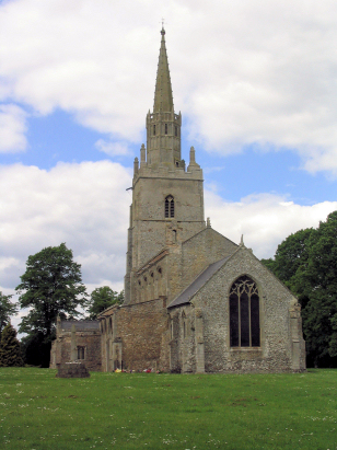
Methwold St George
| |
England
& Wales Hardwicke Marriage Index |
The ParishThe Parish of Methwold lies in southwestern Norfolk not too far both borders with neighbouring Cambridgeshire & also with Suffolk. Methwold is located roughly 6 miles north of the Suffolk market town of Brandon and sits on and mostly west of the B1112 road which links the Suffolk town of Lakenheath through to the A134 (Thetford to King's Lynn) road. Methwold is a large village which has a presence along the B1112 but also largely consists of properties along and either side of twin lanes running westwards from that road out into The Fens, there is also a secondary settlement of Methwold Hythe about a mile and a half west of the main village which sits upon the banks of "The Cut-Off Channel", one of Fenland's major drainage schemes. Methwold was once of sufficient size to have dabbled with growing into a market town, a market existed for a short time but has lapsed with Brandon and Lakenheath taking away that business. Methwold sits in something of a unique position, on the edge of Norfolk's share of Fenland but also on the edge of Norfolk's share of Breckland. To the east soils are poor and sheep and the local speciality of rabbits were important economic forces whilst on largely reclaimed land to its west lie the rich agricultural soils of The Fens, intensely cultivated today early gazetteers confirm it was also so at the time of this transcript with an estimated 60% of the parish acreage as arable. Today the eastern quotient of the parish is dominated by large forestry plantations deemed the best use of the poor Breckland soils. Methwold is drained westwards into the Cut-Off Channel, a drainage scheme designed to get the water of the Wissey quickly across the low-lying terrain and into the Great Ouse and thence to the sea through the port of King;s Lynn and The Wash. Methwold is sited at around 15 metres above the sea with Methwold Hythe some 10 metres lower, the general terrain is flat westwards but gently undulating eastwards to local high points which rise almot to 40 metres between Methwold and Weeting. Methwold parish was one of the largest in its county, the large area of reclaimed Fenland boosting its acreage to a little over 13,000 acres, more reminiscent of an upland northern parish than one in the rural south, this acreage would have supported a population of around 1,450 parishioners. In Domesday times Methwold was an equally wealthy place, the largest share was held directly by the King with William de Warenne holding a much smaller portion. Collectively their assets totalled 20 ploughs and some small meadows, there were 2 mills plus a share in a third but it was the 7 fisheries at that time which made Methwold a wealthy holding for the King. |
 |
|
|
|
| Register No | Covering Dates | Deposited With | Register Style | Quality Standard | Comments |
| 1 |
8th May 1754 - 24th December 1812 |
Norfolk Record Office - Reference - PD313/9 |
Standard preprinted and self-numbered combined Banns &
Marriage register with 4 entries per page |
Grade 2 Register - not a perfect read but with a low
likelihood of misreads |
None |
| 2 | 23rd January 1813 - 16th May 1837 | Norfolk Record Office - Reference - PD313/10 | Standard Rose style preprinted and prenumbered Marriage register | Grade 2 Register - not a perfect read but with a low likelihood of misreads | None |
|
Hilgay
All Saints
West Dereham St Andrew |
Northwold
St Andrew
|
|
|
Hilgay
All Saints
Southery St Mary the Virgin |
 |
Cranwich
St Mary the Virgin
|
|
Southery
St Mary the Virgin
|
Cranwich
St Mary the Virgin
|
1760 1770 1780 1790 1800 1810 1820 1830
Corrections to Tinstaafl Transcripts