
England
& Wales Hardwicke Marriage Index
Marriages
1754 - 1837
Albourne St Bartholomew
| |
England
& Wales Hardwicke Marriage Index |
The ParishThe parish of Albourne lies in southern central Sussex about 2 miles west of the small market town of Hurstpierpoint. Albourne once sat on the busy London to Brighton A23 road, which has nowadays been upgraded to dual-carriageway and moved to the east, the former route being renumbered as B2118. The presence of the major coaching route to the sea saw Albourne greatly expand in Victorian times to serve this transient community, prior to that it was just a rather average mid-sized farming village. Albourne is drained westwards by a small tributary of the Adur which is joined to the northwest of Henfield, the Adur reaches the English Channel through the port of Shoreham on Sea. Albourne is sited at around 40 metres above the sea in fairly tranquil Wealden countryside, local heights within a couple of miles rise to no more than 60 metres whilst the escarpment of the South Downs dominates views to the south. Albourne parish was fairly typically sized for a Wealden parish, it covered close to 1,400 acres and its population would have risen during the period of this transcript to almost 400 parishioners. Albourne is not specifically mentioned in Domesday Book which has many areas of waste within the Weald. |
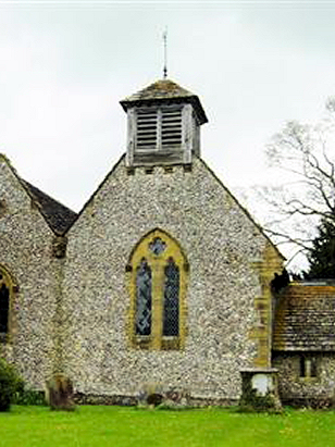 |
The ChurchSt Bartholomew's church actually sits at Albourne Place almost 3/4s of a mile southwest of the village and accessed along a narrow and winding dead-end lane. Sadly the church is a Victorian replacement for Albourne's original building although the architect has copied the styles of the former building indicating that what is lost was a Norman Romanesque origin in the 12th century. The building that now stands here is not the venue for the following marriages having been built in 1859. Whilst the church is maturing into a picturesque part of the landscape it clearly did not excite Pevsner who's text is short and largely descriptive. Church Lane heads westwards from the B2118 before turning sharply south to the church where parking is available on the often muddy verges. The churchyard is surrounded by a mid-height local stone wall and is compact with trees tight to the favoured southeastern aspects which take way the better angles for photography, |
|
|
| Register No | Covering Dates | Deposited With | Register Style | Quality Standard | Comments |
| 1 | 11th February 1755 - 26th April 1757 | West Sussex Record Office - Chichester - Reference PAR226/1/1/2 | Plain unruled book a continuation of the extant composite register in contravention of Hardwicke';s segregation requirements | Grade 4 Register - there are notable quality issues with this register which may have resulted in many misreads | Badly faded requiring assistance from the BTs to achieve a transcript |
| 2 | 2nd January 1759 - 21st May 1785 | West Sussex Record Office - Chichester | Bishop's Transcripts on loose leaf folios | Grade 4 Register - there are notable quality issues with this register which may have resulted in many misreads | The marriage register for this period has been lost, BTs were used to retrieve at least some of these entries, the quality was very mixed and some misreads are likely, also there are certain gaps |
| 3 | 1786 - 1812 | Marriages were not recorded in the BTs for this period | |||
| 4 | 16th August 1813 - 24th February 1837 | West Sussex Record Office - Chichester - Reference PAR226/1/3/1 | Standard Rose style preprinted and prenumbered Marriage register | Grade 2 Register - not a perfect read but with a low likelihood of misreads | None |
|
Woodmancote
St Peter
|
 |
|
|
Poynings
Holy Trinity
|
Poynings
Holy Trinity
|
Corrections to Tinstaafl Transcripts