
England
& Wales Hardwicke Marriage Index
Marriages
1754 - 1837
Shustoke St Cuthbert
| |
England
& Wales Hardwicke Marriage Index |
The ParishThe parish of Shustoke lies centrally in northern Warwickshire roughly midway between the city of Birmingham (12 miles east of that) and Nuneaton (10 miles west of there). Shustoke sits on the B4114 road which links Nuneaton with Coleshill. Shustoke has two distinct settlements, the main village to the west and built around a "T" junction whilst the smaller settlement of Church End, holding the parish church, of course, lies a mile east along the B4114. Like most rural Warwickshire villages Shustoke was essentially a farming community, here the rich oils made arable farming the majority portion of that regime. Modern developments have come to the area, the Birmingham to Nuneaton railway line runs through the parish without giving Shustoke a station, whilst to the west the branch to Tamworth skirts the parish. Of most significance to the land use is the construction of the Shustoke Reservoir which dams the small stream of the Bourne Brook. That Bourne Brook drains the parish westwards the short distance to the River Tame which turns northwards eventually meeting the Trent at Alrewas and thence on a long journey to the North Sea arriving through the Humber Estuary. Shustoke is sited at around 80 metres above the sea in gently rolling countryside where local heights reach 142 metres within a couple of miles. Shustoke parish consisted of two distinct portions, both roughly equal in extent, the main parish was augmented by Bentley chapelry, detached and lying to the northeast, Bentley chapelry was not licensed for marriages in the transcript period. Together the two area totalled almost 3,800 acres making that area one of the county's larger parishes, within that acreage would have been supported close to 650 parishioners. In Domesday times Shustoke was an altogether more modest place, held by one Geoffrey de la Guerche it could muster just 4 ploughs together with the usual meadows & woodland. |
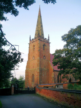 |
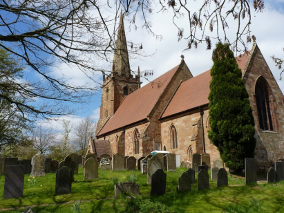
As
stated St Cuthbert's church lies at the eastern settlement, Church
End and sits to the east of the B4114 which performs a distinct
set of right-angled bends to pass through Church End. Outwardly St
Cuthbert looks like a church of the 14th century but all is
illusion as this is a church which has met with repeated disaster
and consequent rebuilding. The western tower retains some medieval
but has been repeatedly struck by lightning in 1777 & 1802
necessitating repair. A substantial Victorian restoration of the
1870s has already seen much of the medieval swept away in both
nave & chancel. That restoration, in turn was to be swept away
in the biggest disaster to strike the church, in the mid 1880s a
disastrous fire swept through the nave and chancel destroying the
work of that restoration and leaving the main body a roofless
shell. What we see today is the rebuilt church in homage to its
original style. A short tarred spur-road leads down to the
churchyard but has no turning circles so car-users are advised to
park and walk unless they are capable of a long narrow reverse. At
the far end wooden gates and the brick-walled bordered churchyard
greet you, a pair of trees dominate the southern aspect removing
the desired landscape view but otherwise all is open for the
photographer. |
|
|
| Register No | Covering Dates | Deposited With | Register Style | Quality Standard | Comments |
| 1 |
15th October 1754 - 23rd November 1812 |
Warwickshire County Record Office - Reference - DRB0048/4 |
Standard preprinted and self-numbered combined Banns &
Marriage register with 4 entries per page |
Grade 4 Register - there are notable quality issues with
this register which may have resulted in many misreads |
Fading is a constant issue throughout but some entries
almost defy legibility leading to a likelihood of some misreads |
| 2 | 26th July 1813 - 18th May 1837 | Warwickshire County Record Office - Reference - DRB0048/5 | Standard Rose style preprinted and prenumbered Marriage register | Grade 4 Register - there are notable quality issues with this register which may have resulted in many misreads | Fading is a constant issue throughout but some entries almost defy legibility leading to a likelihood of some misreads |
|
Curdworth
St Nicholas & St Peter ad Vincula
Baxterley (from Bentley) |
||
 |
||
1760 1770 1780 1790 1800 1810 1820 1830
Corrections to Tinstaafl Transcripts