
England
& Wales Hardwicke Marriage Index
Marriages
1754 - 1837
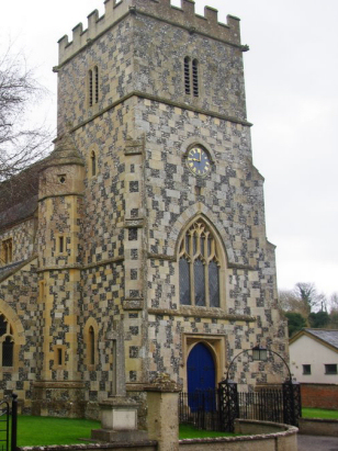
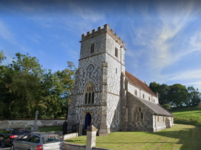
Chitterne All Saints
| |
England
& Wales Hardwicke Marriage Index |
The ParishThe parish of Chitterne All Saints lies in southern central Wiltshire roughly 7 miles east of the market town of Warminter. The village of Chitterne, home to both All Saints & St Mary's parishes, sits on and immediately north of the B390 road which connects Heytesbury with Shrewton. Even today Chitterne shows two faces, the portion of All Saints largely being confined to a valley running northwards from the B390 whilst that of St Mary lines that road to the west. Chitterne sits upon chalk and its position was created as a spring-line settlement where the water-table first creates a flowing stream, to the north most water sits sub-surface. The landscape surrounding Chitterne is part of the early landscapes preserved on the thin-soiled downlands with tumuli, barrows and ancient field systems documented on modern Ordnance Survey maps. Sitting within the Wiltshire Downs Chitterne's economy would have been dominated by the grazing of sheep, largely for the wool trade, today much of the downland has been ploughed and is definitely arable. In modern times the downland has been requisitioned by the army and most of the land to Chitterne's north is out-of-bounds being within the firing ranges of the Imber Ranges. The small stream which rises within sight of All Saints' church drains the parish southwards soon meeting the River Wylye, that heads southeast merging, in turn with the Nadder and then the Avon before reaching the south coast and the English Channel through Christchurch Harbour. Chitterne is sited at around 90 metres above the sea but spreading downland rises mostly northwards reaching 189 metres at the nearby Knook Barrow site. All Saints' parish was the larger of the two parishes by both acreage and population, the parish covered almost 4,300 acres of mostly downland and supported a population of close to 400 parishioners. Even in Domesday times Chitterne was shared by two landowners, perhaps the origins of the two parishes lies with the separate manors held by Edward of Salisbury & Earl Aubrey de Courcy; collectively the two manors totalled 13 ploughs and the usual meadows, pastures & woodland. |
 |
|
|
|
| Register No | Covering Dates | Deposited With | Register Style | Quality Standard | Comments |
| 1 | 29th June 1754 - 1st November 1812 | Wiltshire & Swindon History Centre - Reference - PR/073/1/2 | Standard preprinted and self-numbered combined Banns & Marriage register with 4 entries per page | Grade 2 Register - not a perfect read but with a low likelihood of misreads | None |
| 2 | 11th July 1813 - 14t April 1836 | Wiltshire & Swindon History Centre - Reference - PR/073/1/3 | Standard Rose style preprinted and prenumbered Marriage register | Grade 2 Register - not a perfect read but with a low likelihood of misreads | None |
|
Knook
St Margaret
|
 |
Maddington
St Mary
|
|
Upton
Lovell St Peter
Chitterne St Mary |
Chitterne
St Mary
|
Maddington
St Mary
|
1760 1770 1780 1790 1800 1810 1820 1830
Corrections to Tinstaafl Transcripts