
England
& Wales Hardwicke Marriage Index
Marriages
1754 - 1837
Settrington All Saints
| |
England
& Wales Hardwicke Marriage Index |
The ParishThe parish of Settrington lies in southern central Yorkshire roughly 4 miles east of the market town of Malton, the parish forms a part of the border between the North & East Ridings being within the latter. Settrington is located between 2 & 3 miles south of the A64 road which links Malton through to Scarborough. Much of Settrington sits on a narrow oblong of north to south lanes, each on either side of the small stream, Settrington Beck, which runs through the heart of the village. Settrington is very uch a planned estate village with most properties prettily rebuilt in the late 18th century. Settrington sits on the northern edge of the Yorkshire Wolds with Thorpe Bassett Wold swelling immediately to its east. Although Settrington was an extensive parish it was characterised by being largely in the hands of a single individual, for much of this period it was one Henry Willoughby. Whilst this did not result in a closed village it did restrict economic activities to those dominated by the needs of that estate, on the higher ground sheep would have dominated whilst in the valley a more mixed regime of both cattle & cereals could be found. Modern developments have come & gone from Settrington, the branch railway line linking Malton with Great Driffield having closed and been largely dismantled. The Settrington Beck drains the parish northwards the short distance to join the Derwent where matters turn southwest and south, merging with the Yorkshire Dales rivers to meet the North Sea through the Humber Estuary. Settrington is sited at between 30 & 40 metres above the sea but the proximity of the nearby Wolds raises land sharply to the east topping out at 199 metres at nearby Settrington Beacon, a traditional beacon site for transmitting messages across the land in early times. An extensive parish for a relatively lowland one, Settrington parish covers close to 4,300 acres within which roughly 750 parishioners would have been supported. In Domesday times Settrington was a relatively modest settlement, held by one Berendar de Tosny it could muster just 8 ploughs and a small meadow |
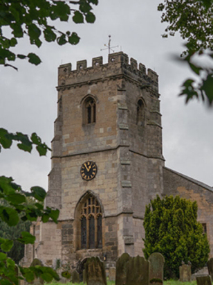 |
All
Saints' church sits towards the southeastern corner of the
village, at the southern end of Church Lane and cheek-by-jowl with
Settrington House, a late 18th century
stone-built house of the local estate owners. Externally the
church appears to be a typical Perpendicular edifice from the late
14th or early 15th centuries. Pevsner, however, shows us that the
church has older credentials with him dating the arcades as early
13th century and Early English Gothic in style. A 13th century
southern porch was demolished in 1823 but its heraldry was reused
proving it too was of this period. Whilst these early features are
minimal the Perpendicular is found throughout the remainder. The
western tower is a particularly fine example of the style despite
losing its spire which had to be removed in the early 17th century
for safety reasons. Restoration came early to All Saints' the
Georgians were active as early as that 1823 demolishing and
further work can be found, particularly in the windows of 1845
& 1868. As recently as 1951 a eastern chapel was created to
complete today's church. Church Lane has a small parking area
outside the churchyard which has a pathway leading to the church.
From a photographer's perspective the placement of the church in
the southeastern corner of a tree-border churchyard is unfortunate
as that removes the more favoured aspects from the portfolio, as a
consequence the church is a tricky subject to obtain a typical
landscape view.
|
|
|
| Register No | Covering Dates | Deposited With | Register Style | Quality Standard | Comments |
| 1 |
21st May 1754 - 14th December 1812 |
Borthwick Institute - York - Reference - PR/SET/4 |
Standard preprinted and self-numbered combined Banns &
Marriage register with 4 entries per page |
Grade 3 Register - there are sufficient quality issues
with this register to indicate that some misreads will occur
albeit few in number |
Poor handwriting at times may result in one or two misreads |
| 2 | 19th January 1813 - 18th March 1837 | Borthwick Institute - York - Reference - PR/SET/6 | Standard Rose style preprinted and prenumbered Marriage register | Grade 2 Register - not a perfect read but with a low likelihood of
misreads |
None |
|
Rillington
St Andrew
|
Thorpe
Bassett All Saints
|
|
|
Norton
St Peter
|
 |
|
|
Wharram
le Street St Mary
|
1760 1770 1780 1790 1800 1810 1820 1830
Corrections to Tinstaafl Transcripts